Trail Walking Housseras - Orage sur la Mortagne (Autrey) - Photo

Orage sur la Mortagne (Autrey)

 tracegps
tracegps

User

© OpenStreetMap contributors
Length
Length
7.9 km
Max alt
Max alt
513 m
Uphill gradient
Uphill gradient
230 m
Km-Effort
Km-Effort  
11 km
Min alt
Min alt
360 m
Downhill gradient
Downhill gradient
229 m
Boucle
Boucle
Yes
Creation date :
2014-12-10 00:00:00.0
Updated on :
2014-12-10 00:00:00.0

(0 Reviews)

Walking
Walking
2h30
Difficulty : Medium

Scan this QR Code to open this trail in the SityTrail application

FREE GPS app for hiking

Logo SityTrail SityTrail

IGN / Geographical institutes

Download SityTrail from the App Store Download SityTrail from Google Play

Logo SityTrail SityTrail World

The world is yours!

Download SityTrail from the App Store Download SityTrail from Google Play Download SityTrail on Huawei AppGallery

About

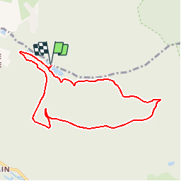
Trail Walking of 7.9 km to be discovered at Grand Est, Vosges, Housseras. This trail is proposed by tracegps.

Description

Circuit proposé par le Comité Départemental du Tourisme des Vosges et le Syndicat d’Initiative de Rambervillers. Accès : De Saint-Dié, prendre la direction de Rambervillers par la D 32, en passant par le col du Haut du Bois. Au centre du village de Fraispertuis, prendre à gauche la direction de Housseras. Passer le village en direction d'Autrey. Au carrefour (calvaire) prendre la route de gauche vers le Hameau des Angles et la maison forestière de Gondremer. Se garer aux environs de la maison forestière Départ : Maison forestière de Gondremer. Retrouvez le descriptif et la carte sur le site du Comité Départemental du Tourisme des Vosges. Rappel : Dans le massif Vosgien, n’oubliez pas de vous munir de la carte IGN avec le balisage du Club Vosgien. Ce circuit a été numérisé par les randonneurs du CODEPEM. Merci à Jean-Marie.

Elevation profile

Photos

Positioning

Country:
France
Region :
Grand Est
Department/Province :
Vosges
Municipality :
Housseras
Location:
Unknown
Start:(UTM)
331430 ; 5351080 (32U) N.

Trails nearby

Trail Walking Fremifontaine - fremifontaine - Photo
Walking
michelbauby

Walking

Easy
Fremifontaine, Grand Est, Vosges, France
10.8 km | 14.2 km-effort
2h 19min
Yes
Trail Horseback riding Jeanménil - Forêt de jeanmenil - Photo
Horseback riding
ACPL

Horseback riding

Easy
Jeanménil, Grand Est, Vosges, France
12 km | 15 km-effort
2h 5min
No
Trail Walking Autrey - Balade à Gondremer - Photo
Walking
Regisconraud

Walking

Medium
Autrey, Grand Est, Vosges, France
5.9 km | 7.7 km-effort
2h 16min
Yes
Trail Walking La Bourgonce - Mont Repos - Photo
Walking
Pascal Raon

Walking

Difficult
La Bourgonce, Grand Est, Vosges, France
10.8 km | 14.3 km-effort
3h 49min
Yes
Trail Mountain bike Jeanménil - Fraip-La Chipotte- St Rémy - Photo
Mountain bike
Herve88

Mountain bike

Medium
Jeanménil, Grand Est, Vosges, France
37 km | 46 km-effort
3h 52min
Yes
Trail Mountain bike Jeanménil - Fraispertuis Housseras  - Photo
Mountain bike
Herve88

Mountain bike

Medium
Jeanménil, Grand Est, Vosges, France
21 km | 27 km-effort
2h 37min
Yes
Trail Mountain bike Jeanménil - Autour du Haut du Bois - Photo
Mountain bike
Herve88

Mountain bike

Medium
Jeanménil, Grand Est, Vosges, France
43 km | 54 km-effort
3h 34min
Yes
Trail Mountain bike Saint-Gorgon - 110822 - Photo
Mountain bike
jeanvosges

Mountain bike

Medium
Saint-Gorgon, Grand Est, Vosges, France
18 km | 22 km-effort
1h 42min
No
Trail Running Sainte-Hélène - 250722 - Photo
Running
jeanvosges

Running

Very easy
Sainte-Hélène, Grand Est, Vosges, France
7.4 km | 8.8 km-effort
50min
No


Close
My subscriptions