Trail Cycle Bray-sur-Somme - Les Anguillères - Bray sur Somme - Photo

Les Anguillères - Bray sur Somme

 tracegps
tracegps

User

© OpenStreetMap contributors
Length
Length
51 km
Max alt
Max alt
88 m
Uphill gradient
Uphill gradient
533 m
Km-Effort
Km-Effort  
58 km
Min alt
Min alt
32 m
Downhill gradient
Downhill gradient
525 m
Boucle
Boucle
Yes
Creation date :
2014-12-10 00:00:00.0
Updated on :
2014-12-10 00:00:00.0

(0 Reviews)

Cycle
Cycle
3h00
Difficulty : Medium

Scan this QR Code to open this trail in the SityTrail application

FREE GPS app for hiking

Logo SityTrail SityTrail

IGN / Geographical institutes

Download SityTrail from the App Store Download SityTrail from Google Play

Logo SityTrail SityTrail World

The world is yours!

Download SityTrail from the App Store Download SityTrail from Google Play Download SityTrail on Huawei AppGallery

About

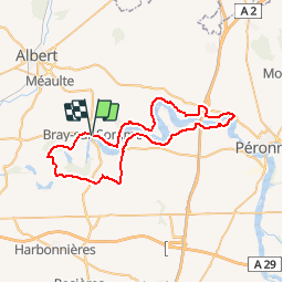
Trail Cycle of 51 km to be discovered at Hauts-de-France, Somme, Bray-sur-Somme. This trail is proposed by tracegps.

Description

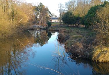
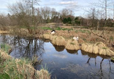
Les Anguillères - Bray sur Somme Départ : place de Bray-sur-Somme. Un circuit pour découvrir la vallée de la Haute Somme où la pêche à l’anguille était très développée à une certaine époque. Vous pourrez encore apercevoir quelques anguillères : sorte de « pièges » permettant de capturer les anguilles pendant leur migration. À voir : Froissy : le p’tit train de la Haute Somme Bray-sur-Somme : musée d’histoire locale, église Saint-Nicolas Vaux : belvédère : point de vue sur les étangs de la Somme. Cappy : église classée Monument Historique, base nautique et halte fluviale.

Elevation profile

Photos

Positioning

Country:
France
Region :
Hauts-de-France
Department/Province :
Somme
Municipality :
Bray-sur-Somme
Location:
Unknown
Start:(UTM)
479763 ; 5531923 (31U) N.

Trails nearby

Trail Walking Cappy - Les Marais de Suzanne - Cappy - Photo
Walking
tracegps

Walking

Medium
(1)
Cappy, Hauts-de-France, Somme, France
11.2 km | 13.2 km-effort
2h 45min
Yes
Trail Walking Étinehem-Méricourt - Les marais des vaches - Photo
Walking
Baltykatt

Walking

Medium
(1)
Étinehem-Méricourt, Hauts-de-France, Somme, France
10.6 km | 12 km-effort
3h 30min
Yes
Trail Walking Étinehem-Méricourt - les Marais des Vaches  - Photo
Walking
José800

Walking

Medium
Étinehem-Méricourt, Hauts-de-France, Somme, France
12.3 km | 13.9 km-effort
3h 11min
Yes
Trail On foot Étinehem-Méricourt - Les Marais de la Violette - Photo
On foot
PRO

On foot

Easy
Étinehem-Méricourt, Hauts-de-France, Somme, France
7.8 km | 8.6 km-effort
1h 57min
Yes
Trail On foot Cappy - Les Royards - Photo
On foot
PRO

On foot

Easy
Cappy, Hauts-de-France, Somme, France
8.9 km | 10.4 km-effort
2h 22min
Yes
Trail Walking Étinehem-Méricourt - le marais des vaches - Photo
Walking
terminio

Walking

Very easy
Étinehem-Méricourt, Hauts-de-France, Somme, France
11.5 km | 13.4 km-effort
2h 49min
Yes
Trail Walking Cappy - Les Champs Muraine - Cappy - Photo
Walking
tracegps

Walking

Medium
Cappy, Hauts-de-France, Somme, France
9.9 km | 11.9 km-effort
2h 15min
Yes
Trail Walking Chuignolles - CHUIGNOLLES - 80 Circuit du gros canon - Photo
Walking
temmichel

Walking

Medium
Chuignolles, Hauts-de-France, Somme, France
9.3 km | 11.2 km-effort
2h 33min
Yes
Trail Walking Bray-sur-Somme - Bray sur Somme - Photo
Walking
jpblimond

Walking

Difficult
Bray-sur-Somme, Hauts-de-France, Somme, France
24 km | 26 km-effort
5h 32min
Yes


Close
My subscriptions