


Puy de seycheuse

xav34830
User
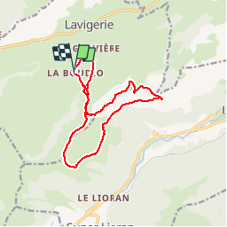

Length
14.6 km

Max alt
1686 m

Uphill gradient
894 m
Km-Effort
27 km

Min alt
1085 m

Downhill gradient
892 m
Boucle
Yes
Creation date :
2019-05-06 10:24:53.493
Updated on :
2019-05-06 10:24:53.493
4h37
Difficulty : Medium

FREE GPS app for hiking
 SityTrail
IGN / Geographical institutes
SityTrail Plus
The world is yours!
About
Trail Walking of 14.6 km to be discovered at Auvergne-Rhône-Alpes, Cantal, Lavigerie. This trail is proposed by xav34830.
Positioning
Country:
France
Region :
Auvergne-Rhône-Alpes
Department/Province :
Cantal
Municipality :
Lavigerie
Location:
Unknown
Start:(Dec)
Start:(UTM)
479485 ; 4996922 (31T) N.
Comments