


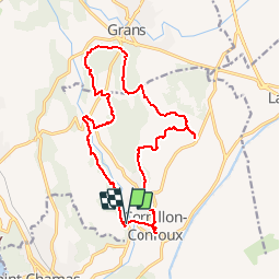
9331112 cornillon confoux 18km

mic-13
User

Length
18.4 km

Max alt
117 m

Uphill gradient
282 m
Km-Effort
22 km

Min alt
31 m

Downhill gradient
297 m
Boucle
Yes
Creation date :
2019-04-23 15:55:08.155
Updated on :
2019-04-23 15:55:08.211
--
Difficulty : Easy

FREE GPS app for hiking
 SityTrail
IGN / Geographical institutes
SityTrail Plus
The world is yours!
About
Trail Walking of 18.4 km to be discovered at Provence-Alpes-Côte d'Azur, Bouches-du-Rhône, Cornillon-Confoux. This trail is proposed by mic-13.
Positioning
Country:
France
Region :
Provence-Alpes-Côte d'Azur
Department/Province :
Bouches-du-Rhône
Municipality :
Cornillon-Confoux
Location:
Unknown
Start:(Dec)
Start:(UTM)
666638 ; 4825344 (31T) N.
Comments