


VALESCREUS -TOUDON AR

Benteux
User
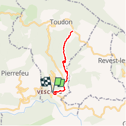

Length
11.6 km

Max alt
960 m

Uphill gradient
843 m
Km-Effort
23 km

Min alt
320 m

Downhill gradient
846 m
Boucle
Yes
Creation date :
2019-05-06 10:32:40.292
Updated on :
2019-05-06 10:32:40.292
6h38
Difficulty : Difficult

FREE GPS app for hiking
 SityTrail
IGN / Geographical institutes
SityTrail Plus
The world is yours!
About
Trail Walking of 11.6 km to be discovered at Provence-Alpes-Côte d'Azur, Maritime Alps, Toudon. This trail is proposed by Benteux.
Photos


Positioning
Country:
France
Region :
Provence-Alpes-Côte d'Azur
Department/Province :
Maritime Alps
Municipality :
Toudon
Location:
Unknown
Start:(Dec)
Start:(UTM)
347967 ; 4858696 (32T) N.
Comments