


Petit Som du pont des allemands

Mariolebeno
User
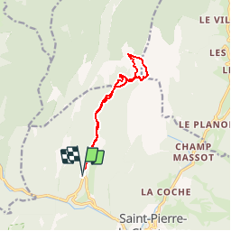

Length
10.8 km

Max alt
1753 m

Uphill gradient
931 m
Km-Effort
23 km

Min alt
838 m

Downhill gradient
936 m
Boucle
Yes
Creation date :
2019-05-06 10:36:06.213
Updated on :
2019-05-06 10:36:06.213
3h00
Difficulty : Medium

FREE GPS app for hiking
 SityTrail
IGN / Geographical institutes
SityTrail Plus
The world is yours!
About
Trail Other activity of 10.8 km to be discovered at Auvergne-Rhône-Alpes, Isère, Saint-Pierre-de-Chartreuse. This trail is proposed by Mariolebeno.
Description
Chartreuse - rando à ski
téléchargé de Skitour
Positioning
Country:
France
Region :
Auvergne-Rhône-Alpes
Department/Province :
Isère
Municipality :
Saint-Pierre-de-Chartreuse
Location:
Unknown
Start:(Dec)
Start:(UTM)
718359 ; 5026226 (31T) N.
Comments