Trail Walking Montigny-en-Cambrésis - Circuit du Tronquoy - Montigny en Cambrésis - Photo

Circuit du Tronquoy - Montigny en Cambrésis

 tracegps
tracegps

User

© OpenStreetMap contributors
Length
Length
12.4 km
Max alt
Max alt
162 m
Uphill gradient
Uphill gradient
108 m
Km-Effort
Km-Effort  
13.8 km
Min alt
Min alt
119 m
Downhill gradient
Downhill gradient
108 m
Boucle
Boucle
Yes
Creation date :
2014-12-10 00:00:00.0
Updated on :
2014-12-10 00:00:00.0

(1 Reviews)

Walking
Walking
3h00
Difficulty : Medium

Scan this QR Code to open this trail in the SityTrail application

FREE GPS app for hiking

Logo SityTrail SityTrail

IGN / Geographical institutes

Download SityTrail from the App Store Download SityTrail from Google Play

Logo SityTrail SityTrail World

The world is yours!

Download SityTrail from the App Store Download SityTrail from Google Play Download SityTrail on Huawei AppGallery

About

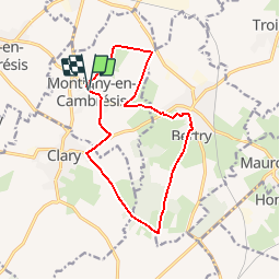
Trail Walking of 12.4 km to be discovered at Hauts-de-France, Nord, Montigny-en-Cambrésis. This trail is proposed by tracegps.

Description

Circuit proposé par le Comité Départemental du Tourisme du Nord. Départ de l’église de Montigny-en-Cambrésis Ce circuit traverse le « plateau boisé » du Cambrésis, vallonné et entrecoupé de ruisseaux. Chemins agricoles, anciennes routes pavées et petites voies champêtres constituent le support de cette agréable promenade adaptée au public familial comme au randonneur plus assidu. Retrouvez cette randonnée sur le site du Comité Départemental du Tourisme du Nord.

Elevation profile

Photos

Positioning

Country:
France
Region :
Hauts-de-France
Department/Province :
Nord
Municipality :
Montigny-en-Cambrésis
Location:
Unknown
Start:(UTM)
529257 ; 5548860 (31U) N.

Comments

Please log in to post a review or rate the element


Trails nearby

Trail Walking Inchy - Circuit d'Audencourt (Inchy) - Photo
Walking
tracegps

Walking

Medium
Inchy, Hauts-de-France, Nord, France
10.4 km | 11.7 km-effort
2h 34min
Yes
Trail Cycle Fontaine-au-Pire - Les Mulquiniers: Panorama du Cambresis - Photo
Cycle
tracegps

Cycle

Medium
Fontaine-au-Pire, Hauts-de-France, Nord, France
39 km | 43 km-effort
3h 30min
Yes
Trail Walking Beaumont-en-Cambrésis - Randonnée de 13.5 km en partant de Beaumont en Cambresis - Photo
Walking
tracegps

Walking

Medium
Beaumont-en-Cambrésis, Hauts-de-France, Nord, France
13.5 km | 15.1 km-effort
2h 15min
Yes
Trail Walking Caudry - Randonnée de 16 km en partant de Caudry - Photo
Walking
tracegps

Walking

Medium
Caudry, Hauts-de-France, Nord, France
16.2 km | 17.8 km-effort
2h 30min
Yes
Trail Walking Fontaine-au-Pire - 22.5km en partant de Fontaine au Pire - Photo
Walking
tracegps

Walking

Medium
Fontaine-au-Pire, Hauts-de-France, Nord, France
21 km | 24 km-effort
3h 30min
Yes
Trail Road bike Troisvilles - secteur pavé de Paris Roubaix - Photo
Road bike
famiski

Road bike

Very easy
Troisvilles, Hauts-de-France, Nord, France
29 km | 32 km-effort
1h 42min
Yes


Close
My subscriptions