Trail Cycle Courcelles-Chaussy - Circuit vélo des Deux Nieds - Photo

Circuit vélo des Deux Nieds

 tracegps
tracegps

User

© OpenStreetMap contributors
Length
Length
25 km
Max alt
Max alt
284 m
Uphill gradient
Uphill gradient
366 m
Km-Effort
Km-Effort  
30 km
Min alt
Min alt
201 m
Downhill gradient
Downhill gradient
366 m
Boucle
Boucle
Yes
Creation date :
2014-12-10 00:00:00.0
Updated on :
2014-12-10 00:00:00.0

(0 Reviews)

Cycle
Cycle
2h00
Difficulty : Difficult

Scan this QR Code to open this trail in the SityTrail application

FREE GPS app for hiking

Logo SityTrail SityTrail

IGN / Geographical institutes

Download SityTrail from the App Store Download SityTrail from Google Play

Logo SityTrail SityTrail World

The world is yours!

Download SityTrail from the App Store Download SityTrail from Google Play Download SityTrail on Huawei AppGallery

About

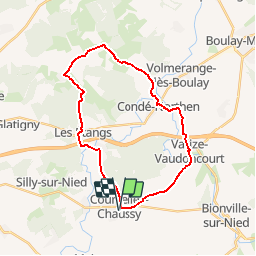
Trail Cycle of 25 km to be discovered at Grand Est, Moselle, Courcelles-Chaussy. This trail is proposed by tracegps.

Description

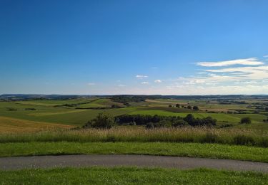
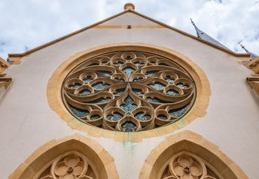
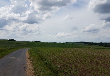
Le circuit d'une longueur de 24 km vous emmène à la découverte d'un territoire rural au patrimoine remarquable et à deux pas de Metz. Cet itinéraire sur routes à faible trafic permet une découverte en toute tranquillité. Quelques efforts seront nécessaires pour aborder ces paysages vallonnés.

Elevation profile

Positioning

Country:
France
Region :
Grand Est
Department/Province :
Moselle
Municipality :
Courcelles-Chaussy
Location:
Unknown
Start:(UTM)
310638 ; 5442665 (32U) N.

Trails nearby

Trail On foot Pange - Circuit des Châteaux - Photo
On foot
PRO

On foot

Easy
Pange, Grand Est, Moselle, France
7.4 km | 8.4 km-effort
1h 54min
Yes
Trail On foot Servigny-lès-Raville - Circuit du Mont Saint-Pierre - Photo
On foot
PRO

On foot

Easy
Servigny-lès-Raville, Grand Est, Moselle, France
10.6 km | 12.9 km-effort
2h 56min
Yes
Trail On foot Courcelles-Chaussy - Circuit de l'Empereur - Photo
On foot
PRO

On foot

Easy
Courcelles-Chaussy, Grand Est, Moselle, France
12.6 km | 14.9 km-effort
3h 22min
Yes
Trail On foot Maizeroy - Circuit du Haut des Oies - Photo
On foot
PRO

On foot

Easy
Maizeroy, Grand Est, Moselle, France
15.3 km | 18.6 km-effort
4h 12min
Yes
Trail Walking Silly-sur-Nied - forêt Silly-sur-Nied  - Photo
Walking
Jeudo

Walking

Easy
Silly-sur-Nied, Grand Est, Moselle, France
5.9 km | 7.3 km-effort
1h 40min
Yes
Trail Walking Pange - ars - Photo
Walking
pistou

Walking

Medium
Pange, Grand Est, Moselle, France
5.6 km | 6.3 km-effort
1h 37min
No
Trail Walking Courcelles-Chaussy - Fer à cheval  - Photo
Walking
Michel

Walking

Easy
Courcelles-Chaussy, Grand Est, Moselle, France
3.2 km | 3.9 km-effort
1h 0min
Yes
Trail Cycle Varize-Vaudoncourt - venetië dag 6 - Photo
Cycle
karawatsj

Cycle

Medium
Varize-Vaudoncourt, Grand Est, Moselle, France
73 km | 83 km-effort
4h 22min
No
Trail Walking Condé-Northen - Condé à Hayes - Photo
Walking
Mri

Walking

Easy
Condé-Northen, Grand Est, Moselle, France
17.2 km | 21 km-effort
Unknown
Yes


Close
My subscriptions