


MONT AUVIERE

Benteux
User

Length
10.7 km

Max alt
957 m

Uphill gradient
673 m
Km-Effort
19.7 km

Min alt
337 m

Downhill gradient
679 m
Boucle
Yes
Creation date :
2019-05-06 11:07:31.393
Updated on :
2019-05-06 11:07:31.393
5h09
Difficulty : Medium

FREE GPS app for hiking
 SityTrail
IGN / Geographical institutes
SityTrail Plus
The world is yours!
About
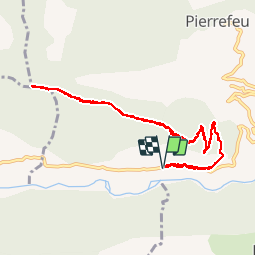
Trail Walking of 10.7 km to be discovered at Provence-Alpes-Côte d'Azur, Maritime Alps, Pierrefeu. This trail is proposed by Benteux.
Photos


Positioning
Country:
France
Region :
Provence-Alpes-Côte d'Azur
Department/Province :
Maritime Alps
Municipality :
Pierrefeu
Location:
Unknown
Start:(Dec)
Start:(UTM)
345062 ; 4857818 (32T) N.
Comments