


mayterie

apa
User
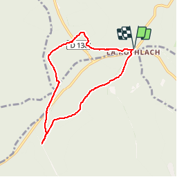

Length
6.7 km

Max alt
1042 m

Uphill gradient
146 m
Km-Effort
8.6 km

Min alt
915 m

Downhill gradient
146 m
Boucle
Yes
Creation date :
2019-05-06 11:15:34.756
Updated on :
2020-01-26 19:01:32.061
3h11
Difficulty : Unknown

FREE GPS app for hiking
 SityTrail
IGN / Geographical institutes
SityTrail Plus
The world is yours!
About
Trail Other activity of 6.7 km to be discovered at Grand Est, Bas-Rhin, Ottrott. This trail is proposed by apa.
Description
Raquette
Photos


Positioning
Country:
France
Region :
Grand Est
Department/Province :
Bas-Rhin
Municipality :
Ottrott
Location:
Unknown
Start:(Dec)
Start:(UTM)
375392 ; 5365306 (32U) N.
Comments