le saule d'Oingt

Thomasdanielle
User
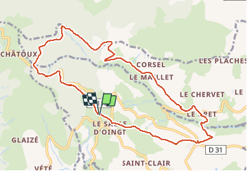

Length
10.7 km

Max alt
712 m

Uphill gradient
401 m
Km-Effort
16 km

Min alt
330 m

Downhill gradient
404 m
Boucle
Yes
Creation date :
2019-05-06 11:16:29.558
Updated on :
2019-05-06 11:16:29.558
3h02
Difficulty : Easy

FREE GPS app for hiking
 SityTrail
IGN / Geographical institutes
SityTrail Plus
The world is yours!
About
Trail Walking of 10.7 km to be discovered at Auvergne-Rhône-Alpes, Rhône, Ville-sur-Jarnioux. This trail is proposed by Thomasdanielle.
Description
31-01-2019
Positioning
Country:
France
Region :
Auvergne-Rhône-Alpes
Department/Province :
Rhône
Municipality :
Ville-sur-Jarnioux
Location:
Unknown
Start:(Dec)
Start:(UTM)
622578 ; 5093041 (31T) N.
Comments