


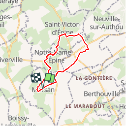
Circuit des Epines - Morsan

tracegps
User


2h30
Difficulty : Medium

FREE GPS app for hiking
 SityTrail
IGN / Geographical institutes
SityTrail Plus
The world is yours!
About
Trail Walking of 9.6 km to be discovered at Normandy, Eure, Morsan. This trail is proposed by tracegps.
Description
Circuit proposé par l’Office de Tourisme du Canton de Brionne . Le dépliant reprenant l’ensemble des circuits est à votre disposition à l’office du Tourisme. Départ de la mairie de Morsan ou de l’église de Notre-Dame-d’Epine. A voir en chemin: Les églises de Morsan et de Notre-Dame-d'Epine et la croix du cimetière à Notre-Dame-d'Epine ainsi que le château de Morsan. Ce circuit a été numérisé par les randonneurs du CODEPEM. Merci à Jean-Marie.
Photos


Positioning
Comments