


MANOSQUE Montaigu

RobinMicheline
User GUIDE
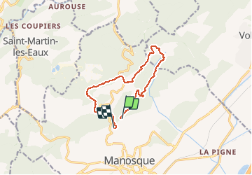

Length
12.5 km

Max alt
684 m

Uphill gradient
425 m
Km-Effort
18.5 km

Min alt
415 m

Downhill gradient
537 m
Boucle
No
Creation date :
2019-05-16 07:39:43.15
Updated on :
2020-01-22 17:54:52.975
3h48
Difficulty : Unknown

FREE GPS app for hiking
 SityTrail
IGN / Geographical institutes
SityTrail Plus
The world is yours!
About
Trail Walking of 12.5 km to be discovered at Provence-Alpes-Côte d'Azur, Alpes-de-Haute-Provence, Manosque. This trail is proposed by RobinMicheline.
Description
13 kms 5 h 540 m deni A REFAIRE


Positioning
Country:
France
Region :
Provence-Alpes-Côte d'Azur
Department/Province :
Alpes-de-Haute-Provence
Municipality :
Manosque
Location:
Unknown
Start:(Dec)
Start:(UTM)
723368 ; 4858802 (31T) N.
Comments