


La Bayonne

aljac
User
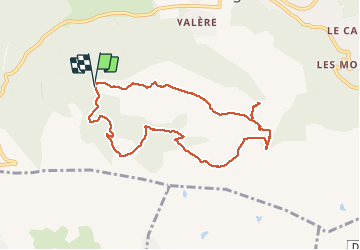

Length
8.6 km

Max alt
419 m

Uphill gradient
325 m
Km-Effort
13 km

Min alt
202 m

Downhill gradient
331 m
Boucle
Yes
Creation date :
2019-04-26 20:32:12.857
Updated on :
2019-04-26 20:32:12.857
2h53
Difficulty : Unknown

FREE GPS app for hiking
 SityTrail
IGN / Geographical institutes
SityTrail Plus
The world is yours!
About
Trail Other activity of 8.6 km to be discovered at Provence-Alpes-Côte d'Azur, Var, Bagnols-en-Forêt. This trail is proposed by aljac.
Positioning
Country:
France
Region :
Provence-Alpes-Côte d'Azur
Department/Province :
Var
Municipality :
Bagnols-en-Forêt
Location:
Unknown
Start:(Dec)
Start:(UTM)
311491 ; 4821872 (32T) N.
Comments