


08-02-2019 Ergal La Richarderie

microb
User
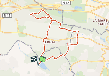

Length
9.2 km

Max alt
177 m

Uphill gradient
205 m
Km-Effort
11.9 km

Min alt
93 m

Downhill gradient
205 m
Boucle
Yes
Creation date :
2019-05-06 14:32:49.382
Updated on :
2019-05-06 14:32:49.382
1h48
Difficulty : Medium

FREE GPS app for hiking
 SityTrail
IGN / Geographical institutes
SityTrail Plus
The world is yours!
About
Trail Nordic walking of 9.2 km to be discovered at Ile-de-France, Yvelines, Maurepas. This trail is proposed by microb.
Description
Maurepas - Launay - La Richarderie - Ergal
Positioning
Country:
France
Region :
Ile-de-France
Department/Province :
Yvelines
Municipality :
Maurepas
Location:
Unknown
Start:(Dec)
Start:(UTM)
420758 ; 5403136 (31U) N.
Comments