


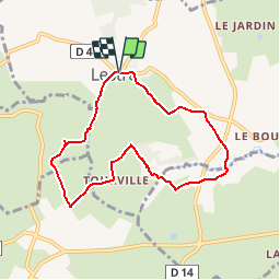
Le circuit du Bouillon - Lestre

tracegps
User


2h00
Difficulty : Medium

FREE GPS app for hiking
 SityTrail
IGN / Geographical institutes
SityTrail Plus
The world is yours!
About
Trail Walking of 7 km to be discovered at Normandy, Manche, Lestre. This trail is proposed by tracegps.
Description
Le circuit du Bouillon - Lestre. Que d’eau, que d’eau !! Entre mer et bocage, l’eau est omniprésente, a gauche, a droite, devant, derrière… Prévoyez des bottes pour ce charmant sentier facile, jalonné de délicieux ponts sur des ruisseaux et de patrimoines bâtis variés. Plus de détails sur le circuit (balisage, difficulté…), les points remarquables à proximité et téléchargements sur Manche Tourisme – Loisirs Randonnée GPS.
Photos

Positioning
Comments
