Trail Walking Bailleul - Sentier du Ravensberg - Bailleul - Photo

Sentier du Ravensberg - Bailleul

 tracegps
tracegps

User

© OpenStreetMap contributors
Length
Length
14.4 km
Max alt
Max alt
70 m
Uphill gradient
Uphill gradient
182 m
Km-Effort
Km-Effort  
16.8 km
Min alt
Min alt
15 m
Downhill gradient
Downhill gradient
182 m
Boucle
Boucle
Yes
Creation date :
2014-12-10 00:00:00.0
Updated on :
2014-12-10 00:00:00.0

(0 Reviews)

Walking
Walking
3h40
Difficulty : Difficult

Scan this QR Code to open this trail in the SityTrail application

FREE GPS app for hiking

Logo SityTrail SityTrail

IGN / Geographical institutes

Download SityTrail from the App Store Download SityTrail from Google Play

Logo SityTrail SityTrail World

The world is yours!

Download SityTrail from the App Store Download SityTrail from Google Play Download SityTrail on Huawei AppGallery

About

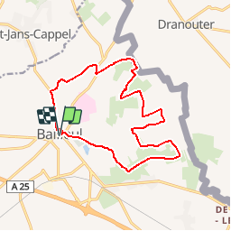
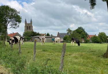
Trail Walking of 14.4 km to be discovered at Hauts-de-France, Nord, Bailleul. This trail is proposed by tracegps.

Description

Circuit proposé par le Comité Départemental du Tourisme du Nord et l’ Office de Tourisme de Bailleul. Fiche n° 26 de la pochette «Il était une fois les Monts de Flandre». Départ devant l’office de Tourisme de Bailleul, Grand’Place. Ce circuit s’adresse au promeneur et à la famille dans sa version courte, au randonneur averti dans sa version longue. Le circuit 10 km est entièrement macadamisé. Il est donc praticable, à pied sec, toute l’année. Le dénivelé cumulé positif pour le circuit 14 km est d’environ 125 m. Attention : Au niveau du centre de phytosociologie suivre le GR 128. Retrouvez cette randonnée sur le site du Comité Départemental du Tourisme du Nord.

Elevation profile

Photos

Positioning

Country:
France
Region :
Hauts-de-France
Department/Province :
Nord
Municipality :
Bailleul
Location:
Unknown
Start:(UTM)
481320 ; 5620866 (31U) N.

Trails nearby

Trail Motor Bailleul - 104 - Photo
Motor
abalcerek

Motor

Very easy
(3)
Bailleul, Hauts-de-France, Nord, France
127 km | 140 km-effort
3h 49min
No
Trail Walking Saint-Jans-Cappel - sentier des jacynthes - Photo
Walking
Bernard.voyageur

Walking

Medium
(1)
Saint-Jans-Cappel, Hauts-de-France, Nord, France
7.3 km | 9.2 km-effort
2h 1min
Yes
Trail Walking Bailleul - camping de la Ferme des Saules à côté de Bailleul, arrivée Deulemont - Photo
Walking
jeff2

Walking

Medium
Bailleul, Hauts-de-France, Nord, France
32 km | 34 km-effort
9h 10min
No
Trail Walking Heuvelland - Dranouter 12,3 km - Photo
Walking
GUIDE
rvapeldo

Walking

Easy
Heuvelland, Flanders, West Flanders, Belgium
12.4 km | 14.5 km-effort
3h 32min
Yes
Trail Walking Heuvelland - Loker 18,2 km - Photo
Walking
GUIDE
rvapeldo

Walking

Medium
Heuvelland, Flanders, West Flanders, Belgium
18.3 km | 23 km-effort
5h 14min
Yes
Trail Walking Boeschepe - Week-end des estaminets CAF1 - Photo
Walking
reneperrin

Walking

Easy
Boeschepe, Hauts-de-France, Nord, France
16.7 km | 21 km-effort
4h 32min
Yes
Trail Running Saint-Jans-Cappel - st jans - mont des cats - mont noir - Photo
Running
jamboxland

Running

Easy
Saint-Jans-Cappel, Hauts-de-France, Nord, France
16.8 km | 21 km-effort
1h 43min
Yes
Trail Walking Saint-Jans-Cappel - Sentier des jacinthes - Photo
Walking

Walking

Very easy
(1)
Saint-Jans-Cappel, Hauts-de-France, Nord, France
6.3 km | 8.1 km-effort
Unknown
Yes
Trail Running Berthen - mont des cats - Photo
Running
jamboxland

Running

Medium
Berthen, Hauts-de-France, Nord, France
11 km | 14.5 km-effort
1h 10min
Yes


Close
My subscriptions