Trail Walking Laheycourt - La boucle du chêne Henriot - Laheycourt - Photo

La boucle du chêne Henriot - Laheycourt

 tracegps
tracegps

User

© OpenStreetMap contributors
Length
Length
15.8 km
Max alt
Max alt
203 m
Uphill gradient
Uphill gradient
175 m
Km-Effort
Km-Effort  
18.1 km
Min alt
Min alt
160 m
Downhill gradient
Downhill gradient
174 m
Boucle
Boucle
Yes
Creation date :
2014-12-10 00:00:00.0
Updated on :
2014-12-10 00:00:00.0

(0 Reviews)

Walking
Walking
4h00
Difficulty : Difficult

Scan this QR Code to open this trail in the SityTrail application

FREE GPS app for hiking

Logo SityTrail SityTrail

IGN / Geographical institutes

Download SityTrail from the App Store Download SityTrail from Google Play

Logo SityTrail SityTrail World

The world is yours!

Download SityTrail from the App Store Download SityTrail from Google Play Download SityTrail on Huawei AppGallery

About

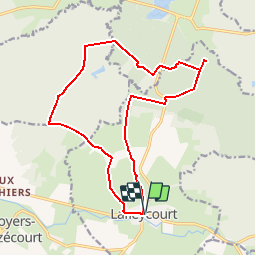
Trail Walking of 15.8 km to be discovered at Grand Est, Meuse, Laheycourt. This trail is proposed by tracegps.

Description

Circuit proposé par la Copary et l’Office de Tourisme de Revigny-sur-Ornain . Départ à l’angle de la mairie et de la rue de la Chée. Cette boucle mène le randonneur au cœur des bois de Bellenoue et de Boudart, qui se distinguent par leurs chênes. Le chêne Henriot est le plus remarquable d’entre-eux. Retrouvez ce circuit sur le site de la Copary et le Guide d’interprétation du circuit. Téléchargez le Guide audio (clic droit, Enregistrer sous) de cette randonnée pour l’écouter sur votre lecteur pendant la balade. Ce circuit a été numérisé par les randonneurs du CODEPEM. Merci à Jean-Marie.

Elevation profile

Photos

Positioning

Country:
France
Region :
Grand Est
Department/Province :
Meuse
Municipality :
Laheycourt
Location:
Unknown
Start:(UTM)
648274 ; 5417244 (31U) N.

Trails nearby

Trail Walking Villers-aux-Vents - La boucle d'Eole - Villers-aux-Vents - Photo
Walking
tracegps

Walking

Medium
Villers-aux-Vents, Grand Est, Meuse, France
7.9 km | 8.9 km-effort
2h 0min
Yes
Trail Cycle Villotte-devant-Louppy - Découverte de la campagne Meusienne - Villotte-devant-Louppy - Photo
Cycle
tracegps

Cycle

Medium
Villotte-devant-Louppy, Grand Est, Meuse, France
16.2 km | 18.4 km-effort
1h 30min
Yes
Trail Walking Sommeilles - belval - Photo
Walking
ghislaine61

Walking

Easy
Sommeilles, Grand Est, Meuse, France
14.4 km | 16 km-effort
3h 9min
Yes
Trail Walking Sommeilles - vers belval - Photo
Walking
ghislaine61

Walking

Easy
Sommeilles, Grand Est, Meuse, France
8.9 km | 10.1 km-effort
2h 17min
Yes
Trail Other activity Laheycourt - Entre Meuse et Marne - Photo
Other activity
Antoine55800

Other activity

Easy
Laheycourt, Grand Est, Meuse, France
29 km | 33 km-effort
2h 20min
No
Trail Hybrid bike Brabant-le-Roi - 30 km autour de Revigny sur Ornain - Photo
Hybrid bike
norihtom

Hybrid bike

Difficult
Brabant-le-Roi, Grand Est, Meuse, France
30 km | 33 km-effort
2h 0min
Yes
Trail Cycle Brabant-le-Roi - 2018 brabant 4 - Photo
Cycle
norihtom

Cycle

Very easy
Brabant-le-Roi, Grand Est, Meuse, France
30 km | 35 km-effort
2h 2min
Yes
Trail Cycle Brabant-le-Roi - 2018 brabant 3 - Photo
Cycle
norihtom

Cycle

Very easy
Brabant-le-Roi, Grand Est, Meuse, France
22 km | 25 km-effort
19min
Yes


Close
My subscriptions