


Col de port - Estibat

choubaka77
User
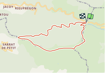

Length
9.3 km

Max alt
1654 m

Uphill gradient
532 m
Km-Effort
16.4 km

Min alt
1166 m

Downhill gradient
533 m
Boucle
Yes
Creation date :
2019-05-06 15:13:00.592
Updated on :
2019-05-06 15:13:00.592
3h19
Difficulty : Unknown

FREE GPS app for hiking
 SityTrail
IGN / Geographical institutes
SityTrail Plus
The world is yours!
About
Trail Walking of 9.3 km to be discovered at Occitania, Ariège, Saurat. This trail is proposed by choubaka77.
Positioning
Country:
France
Region :
Occitania
Department/Province :
Ariège
Municipality :
Saurat
Location:
Unknown
Start:(Dec)
Start:(UTM)
373702 ; 4750764 (31T) N.
Comments