


haut du roc

pascha
User
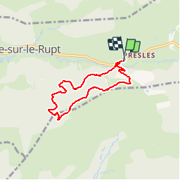

Length
5.9 km

Max alt
1020 m

Uphill gradient
257 m
Km-Effort
9.3 km

Min alt
800 m

Downhill gradient
258 m
Boucle
Yes
Creation date :
2019-05-06 15:13:12.757
Updated on :
2019-05-06 15:13:12.757
2h59
Difficulty : Medium

FREE GPS app for hiking
 SityTrail
IGN / Geographical institutes
SityTrail Plus
The world is yours!
About
Trail Walking of 5.9 km to be discovered at Grand Est, Vosges, Basse-sur-le-Rupt. This trail is proposed by pascha.
Positioning
Country:
France
Region :
Grand Est
Department/Province :
Vosges
Municipality :
Basse-sur-le-Rupt
Location:
Unknown
Start:(Dec)
Start:(UTM)
335404 ; 5317237 (32T) N.
Comments