Trail Walking Ourouer-les-Bourdelins - Sources et vallons - Ourouer-les-Bourdelins - Photo

Sources et vallons - Ourouer-les-Bourdelins

 tracegps
tracegps

User

© OpenStreetMap contributors
Length
Length
17.9 km
Max alt
Max alt
242 m
Uphill gradient
Uphill gradient
181 m
Km-Effort
Km-Effort  
20 km
Min alt
Min alt
177 m
Downhill gradient
Downhill gradient
180 m
Boucle
Boucle
Yes
Creation date :
2014-12-10 00:00:00.0
Updated on :
2014-12-10 00:00:00.0

(0 Reviews)

Walking
Walking
4h30
Difficulty : Very difficult

Scan this QR Code to open this trail in the SityTrail application

FREE GPS app for hiking

Logo SityTrail SityTrail

IGN / Geographical institutes

Download SityTrail from the App Store Download SityTrail from Google Play

Logo SityTrail SityTrail World

The world is yours!

Download SityTrail from the App Store Download SityTrail from Google Play Download SityTrail on Huawei AppGallery

About

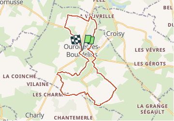
Trail Walking of 17.9 km to be discovered at Centre-Loire Valley, Cher, Ourouer-les-Bourdelins. This trail is proposed by tracegps.

Description

Circuit proposé par le Comité départemental du Tourisme du Cher et l’Office du Tourisme du Pays Loire-Val d’Aubois Départ prés de la chapelle Ourouer-les-Bourdelins Retrouvez le plan du circuit sur le site du Berry. Ce circuit a été numérisé par les randonneurs du CODEPEM . Merci à Jean-Marie.

Elevation profile

Photos

Positioning

Country:
France
Region :
Centre-Loire Valley
Department/Province :
Cher
Municipality :
Ourouer-les-Bourdelins
Location:
Unknown
Start:(UTM)
483601 ; 5197466 (31T) N.

Trails nearby

Trail Moto cross Cornusse - TET-FRANCE-Section16-20201120 - Bourges/ Clermont Ferrand RETRAVAILL - Photo
Moto cross
eric.guyard21

Moto cross

Medium
Cornusse, Centre-Loire Valley, Cher, France
326 km | 409 km-effort
Unknown
No
Trail Trail Flavigny - flavigny - Photo
Trail
levequejef

Trail

Very easy
Flavigny, Centre-Loire Valley, Cher, France
14.9 km | 17.1 km-effort
2h 17min
Yes


Close
My subscriptions