Trail Cycle Samerey - Eurovéloroute Nantes Budapest - Abergement La Ronce à Salans - Photo

Eurovéloroute Nantes Budapest - Abergement La Ronce à Salans

 tracegps
tracegps

User

© OpenStreetMap contributors
Length
Length
48 km
Max alt
Max alt
230 m
Uphill gradient
Uphill gradient
354 m
Km-Effort
Km-Effort  
52 km
Min alt
Min alt
185 m
Downhill gradient
Downhill gradient
324 m
Boucle
Boucle
No
Creation date :
2014-12-10 00:00:00.0
Updated on :
2014-12-10 00:00:00.0

(0 Reviews)

Cycle
Cycle
3h00
Difficulty : Medium

Scan this QR Code to open this trail in the SityTrail application

FREE GPS app for hiking

Logo SityTrail SityTrail

IGN / Geographical institutes

Download SityTrail from the App Store Download SityTrail from Google Play

Logo SityTrail SityTrail World

The world is yours!

Download SityTrail from the App Store Download SityTrail from Google Play Download SityTrail on Huawei AppGallery

About

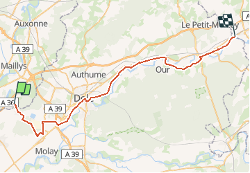
Trail Cycle of 48 km to be discovered at Bourgogne-Franche-Comté, Côte-d'Or, Samerey. This trail is proposed by tracegps.

Description

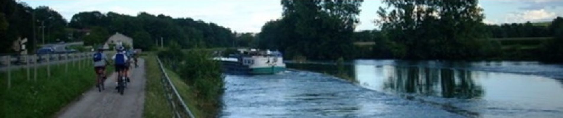
L’Eurovéloroute se situe sur le Nord du département du Jura, elle suit en grande partie le Doubs. Le tracé sur le département permet de rejoindre l’Abergement La Ronce à Salans, à l'exception de : - la partie sur Dole qui n'est pas encore aménagée - sur Tavaux : mise en place d'un tracé provisoire à proximité de l'usine Solvay en attendant le tracé définitif Plus globalement se projet permettra de relier Nantes à Budapest en suivant les Fleuves : Rhin, Danube, Loire, Saône, Doubs et le canal du centre. Une vidéo consacrée à l’Eurovéloroute. Attention, vitesse limitée !

Elevation profile

Photos

Positioning

Country:
France
Region :
Bourgogne-Franche-Comté
Department/Province :
Côte-d'Or
Municipality :
Samerey
Location:
Unknown
Start:(UTM)
678826 ; 5217241 (31T) N.

Trails nearby

Trail Walking Saint-Symphorien-sur-Saône - Samerey 12.2km 20161220 - Photo
Walking
cmike39

Walking

Very easy
Saint-Symphorien-sur-Saône, Bourgogne-Franche-Comté, Côte-d'Or, France
12.2 km | 13 km-effort
2h 54min
Yes
Trail Nordic walking Tavaux - Tavaux_Vernaux_Recepage 8.9 km - Photo
Nordic walking
cmike39

Nordic walking

Easy
Tavaux, Bourgogne-Franche-Comté, Jura, France
8.9 km | 9.7 km-effort
1h 53min
Yes
Trail Walking Damparis - Damparis - Photo
Walking
pje

Walking

Easy
Damparis, Bourgogne-Franche-Comté, Jura, France
10.1 km | 11.6 km-effort
2h 35min
Yes
Trail Walking Champvans - foucherans - Photo
Walking
phileasy

Walking

Very easy
Champvans, Bourgogne-Franche-Comté, Jura, France
8 km | 9.5 km-effort
1h 52min
No
Trail Walking Damparis - Damparis 20210423 - Photo
Walking
cmike39

Walking

Medium
Damparis, Bourgogne-Franche-Comté, Jura, France
7.9 km | 9.9 km-effort
8min
No
Trail Walking Damparis - Damparis 20210319 - Photo
Walking
cmike39

Walking

Very easy
Damparis, Bourgogne-Franche-Comté, Jura, France
14 km | 15.9 km-effort
2h 59min
Yes
Trail Nordic walking Tavaux - Tavaux 9.6 km 20190507 - Photo
Nordic walking
cmike39

Nordic walking

Very easy
Tavaux, Bourgogne-Franche-Comté, Jura, France
9.6 km | 10.5 km-effort
2h 36min
Yes
Trail Nordic walking Tavaux - Tavaux 20180130 - Photo
Nordic walking
cmike39

Nordic walking

Very easy
Tavaux, Bourgogne-Franche-Comté, Jura, France
10 km | 11 km-effort
2h 38min
Yes
Trail Nordic walking Tavaux - tavaux - Photo
Nordic walking
cmike39

Nordic walking

Very easy
Tavaux, Bourgogne-Franche-Comté, Jura, France
9.6 km | 10.5 km-effort
2h 12min
Yes


Close
My subscriptions