Trail Mountain bike Auxon - Sentier de la Tourefaine - Auxon - Photo

Sentier de la Tourefaine - Auxon

 tracegps
tracegps

User

© OpenStreetMap contributors
Length
Length
19.1 km
Max alt
Max alt
409 m
Uphill gradient
Uphill gradient
352 m
Km-Effort
Km-Effort  
24 km
Min alt
Min alt
230 m
Downhill gradient
Downhill gradient
352 m
Boucle
Boucle
Yes
Creation date :
2014-12-10 00:00:00.0
Updated on :
2014-12-10 00:00:00.0

(0 Reviews)

Mountain bike
Mountain bike
1h30
Difficulty : Medium

Scan this QR Code to open this trail in the SityTrail application

FREE GPS app for hiking

Logo SityTrail SityTrail

IGN / Geographical institutes

Download SityTrail from the App Store Download SityTrail from Google Play

Logo SityTrail SityTrail World

The world is yours!

Download SityTrail from the App Store Download SityTrail from Google Play Download SityTrail on Huawei AppGallery

About

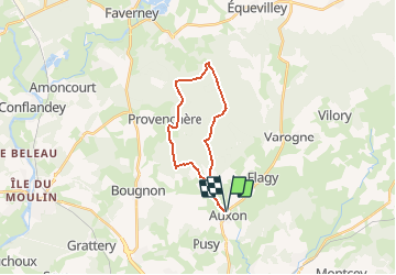
Trail Mountain bike of 19.1 km to be discovered at Bourgogne-Franche-Comté, Haute-Saône, Auxon. This trail is proposed by tracegps.

Description

Circuit proposé par la communauté de communes Agir Ensemble. Départ de la mairie d’Auxon. Intérêt du circuit : Tout au long de votre promenade vous pourrez voir de beaux paysages et avoir une vue imprenable sur la vallée de la Lanterne, les villages de Provenchère et d’Auxon, rejoindre le Château de Saramboz qui se trouve sur la commune d’Auxon, passer à côté de l’Ermitage Saint Laurent. Retrouvez le circuit sur le site de la communauté de communes. Ce circuit a été numérisé par les randonneurs du CODEPEM. Merci à Jean-Marie

Elevation profile

Photos

Positioning

Country:
France
Region :
Bourgogne-Franche-Comté
Department/Province :
Haute-Saône
Municipality :
Auxon
Location:
Unknown
Start:(UTM)
287203 ; 5284970 (32T) N.

Trails nearby

Trail Plane Comberjon - NAV en DA20  LFQW-LFQM-LFEV-LFQW - Photo
Plane
nicolasdresse

Plane

Very easy
Comberjon, Bourgogne-Franche-Comté, Haute-Saône, France
146 km | 197 km-effort
Unknown
No
Trail Walking Auxon - Auxon  - Photo
Walking
normandb

Walking

Medium
Auxon, Bourgogne-Franche-Comté, Haute-Saône, France
7.7 km | 9.6 km-effort
1h 59min
Yes
Trail Walking Coulevon - VILLEPAROIS  -bellenoye- colombier -villeparois - Photo
Walking
nicolasdresse

Walking

Difficult
Coulevon, Bourgogne-Franche-Comté, Haute-Saône, France
12.9 km | 15.8 km-effort
3h 19min
Yes
Trail Walking Auxon - tour 5km - Photo
Walking
normandb

Walking

Medium
Auxon, Bourgogne-Franche-Comté, Haute-Saône, France
5.4 km | 6.2 km-effort
51min
Yes
Trail Walking Villeparois - Villeparois-Flagy  - Photo
Walking
nicolasdresse

Walking

Medium
Villeparois, Bourgogne-Franche-Comté, Haute-Saône, France
7.9 km | 10.1 km-effort
2h 28min
No
Trail Walking Auxon - Ferme d egrevaux  - Photo
Walking
nicolasdresse

Walking

Medium
Auxon, Bourgogne-Franche-Comté, Haute-Saône, France
5.1 km | 6.4 km-effort
1h 47min
Yes
Trail Walking Bougnon -  Bougnon nov21 - Photo
Walking
Jean M

Walking

Easy
Bougnon, Bourgogne-Franche-Comté, Haute-Saône, France
12.2 km | 15.4 km-effort
3h 6min
Yes
Trail Walking Comberjon - Aeroclub  - Photo
Walking
nicolasdresse

Walking

Comberjon, Bourgogne-Franche-Comté, Haute-Saône, France
4 km | 4.6 km-effort
1h 11min
Yes
Trail Walking Auxon - 21 05 2020 - Photo
Walking
traceur70

Walking

Very easy
Auxon, Bourgogne-Franche-Comté, Haute-Saône, France
9.7 km | 11.7 km-effort
2h 12min
Yes


Close
My subscriptions