


montaut fait

pidjam
User
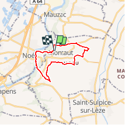

Length
10.2 km

Max alt
300 m

Uphill gradient
236 m
Km-Effort
13.4 km

Min alt
182 m

Downhill gradient
235 m
Boucle
Yes
Creation date :
2019-05-06 15:37:50.664
Updated on :
2019-05-06 15:37:50.664
2h54
Difficulty : Easy

FREE GPS app for hiking
 SityTrail
IGN / Geographical institutes
SityTrail Plus
The world is yours!
About
Trail Walking of 10.2 km to be discovered at Occitania, Haute-Garonne, Montaut. This trail is proposed by pidjam.
Description
Rando balisée en grande partie par "sentes et layons".
Positioning
Country:
France
Region :
Occitania
Department/Province :
Haute-Garonne
Municipality :
Montaut
Location:
Unknown
Start:(Dec)
Start:(UTM)
361733 ; 4801825 (31T) N.
Comments