Trail Walking Coussegrey - Circuit des Dagoniots - Coussegrey - Photo

Circuit des Dagoniots - Coussegrey

 tracegps
tracegps

User

© OpenStreetMap contributors
Length
Length
12.7 km
Max alt
Max alt
241 m
Uphill gradient
Uphill gradient
185 m
Km-Effort
Km-Effort  
15.2 km
Min alt
Min alt
166 m
Downhill gradient
Downhill gradient
185 m
Boucle
Boucle
Yes
Creation date :
2014-12-10 00:00:00.0
Updated on :
2014-12-10 00:00:00.0

(0 Reviews)

Walking
Walking
3h10
Difficulty : Difficult

Scan this QR Code to open this trail in the SityTrail application

FREE GPS app for hiking

Logo SityTrail SityTrail

IGN / Geographical institutes

Download SityTrail from the App Store Download SityTrail from Google Play

Logo SityTrail SityTrail World

The world is yours!

Download SityTrail from the App Store Download SityTrail from Google Play Download SityTrail on Huawei AppGallery

About

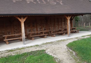
Trail Walking of 12.7 km to be discovered at Grand Est, Aube, Coussegrey. This trail is proposed by tracegps.

Description

Circuit proposé par l’Office du Tourisme du Chaourçois en Pays d’Armance . Départ de la place du village de Coussegrey. A l’origine, Coussegrey s’est appelé Curtis Secreta (cœur secret) ensuite Segredis Curtis (domaine retiré) puis Courcegrey pour enfin et définitivement se nommer Coussegrey et ses habitants les Dagoniots. Mais d’où vient ce nom bizarre qui surprend tant ? Le verbe dagonner qui signifie faire des choses peu utiles, de peu d’importance, apporte peut-être une explication. A voir : Sous le vocable de l’Assomption, l’église est du Xe et XIIe siècle. Surmonté d’un clocher flanqué d’un campanile, elle offre aux visiteurs quelques curiosités. A l’intérieur, des objets d’art, tableaux et statues, pour le=a plupart classés aux monuments historiques, témoignent de son passé religieux. La chapelle St Jacques, la croix et l’oratoire situés sur la route de Prusy constituent un monument complexe. Elevé le 1er avril 1538, il ne comprenait à l’origine que la croix dominant la mise au tombeau. Dégradé à la révolution, le groupe sculpté a été recouvert d’une voûte qui l’étouffe un peu. Les coquillages qui ornent la croix et le monument témoignent du passage des pèlerins se rendant à St Jacques de Compostelle. Retrouvez ce circuit sur le site de l’Office du Tourisme.

Elevation profile

Photos

Positioning

Country:
France
Region :
Grand Est
Department/Province :
Aube
Municipality :
Coussegrey
Location:
Unknown
Start:(UTM)
576005 ; 5311947 (31T) N.

Trails nearby

Trail Walking Coussegrey - Coussegrey 20km le 03.12.2023 - Photo
Walking
francis1952

Walking

Medium
Coussegrey, Grand Est, Aube, France
20 km | 25 km-effort
4h 32min
Yes
Trail Walking Prusy - prusy  - Photo
Walking
richardetchantal

Walking

Very easy
Prusy, Grand Est, Aube, France
14.2 km | 16.6 km-effort
3h 38min
Yes
Trail Walking Prusy - prusy apres midi - Photo
Walking
richardetchantal

Walking

Easy
Prusy, Grand Est, Aube, France
8.1 km | 9.3 km-effort
1h 51min
Yes
Trail Walking Coussegrey - Coussegrey 03/2024 - Photo
Walking
randobe

Walking

Very difficult
Coussegrey, Grand Est, Aube, France
24 km | 28 km-effort
6h 3min
Yes
Trail On foot Coussegrey - coussegrey - Photo
On foot
genndor

On foot

Medium
Coussegrey, Grand Est, Aube, France
24 km | 27 km-effort
6h 14min
Yes
Trail Walking Coussegrey - Coussegrey - Photo
Walking
randobe

Walking

Very difficult
Coussegrey, Grand Est, Aube, France
19.8 km | 24 km-effort
4h 18min
No
Trail Walking Coussegrey - coussegrey 31223 - Photo
Walking
joeljoseph

Walking

Difficult
Coussegrey, Grand Est, Aube, France
10.2 km | 12.2 km-effort
1h 13min
Yes
Trail Walking Coussegrey - Coussegrey - Photo
Walking
randobe

Walking

Very difficult
Coussegrey, Grand Est, Aube, France
20 km | 24 km-effort
5h 52min
Yes
Trail Walking Coussegrey - dagoniots 0412 22 - Photo
Walking
joeljoseph

Walking

Difficult
Coussegrey, Grand Est, Aube, France
16.3 km | 19 km-effort
3h 57min
Yes


Close
My subscriptions