Trail Walking Saint-Pierre-d'Entremont - Vallée du Noireau - Cerisy-Belle-Etoile - Photo

Vallée du Noireau - Cerisy-Belle-Etoile

 tracegps
tracegps

User

© OpenStreetMap contributors
Length
Length
7.7 km
Max alt
Max alt
250 m
Uphill gradient
Uphill gradient
185 m
Km-Effort
Km-Effort  
10.1 km
Min alt
Min alt
104 m
Downhill gradient
Downhill gradient
187 m
Boucle
Boucle
Yes
Creation date :
2014-12-10 00:00:00.0
Updated on :
2014-12-10 00:00:00.0

(1 Reviews)

Walking
Walking
2h19
Difficulty : Medium

Scan this QR Code to open this trail in the SityTrail application

FREE GPS app for hiking

Logo SityTrail SityTrail

IGN / Geographical institutes

Download SityTrail from the App Store Download SityTrail from Google Play

Logo SityTrail SityTrail World

The world is yours!

Download SityTrail from the App Store Download SityTrail from Google Play Download SityTrail on Huawei AppGallery

About

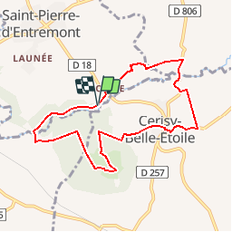
Trail Walking of 7.7 km to be discovered at Normandy, Orne, Saint-Pierre-d'Entremont. This trail is proposed by tracegps.

Description

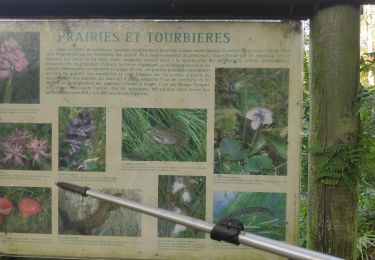
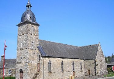
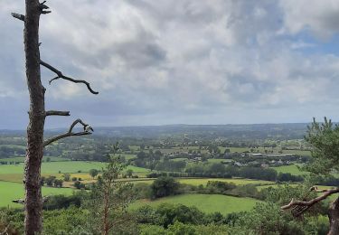
Vallée du Noireau - Cerisy-Belle-Etoile. Le randonneur peut se fier à la Belle Etoile du mont de Cerisy. Elle l'invite à une ascension florale, et lui offre au passage, à la faveur d'un rayon de soleil, quelques instants romantiques. Retrouvez les Coups de Cœur Randonnée dans l’Orne en Normandie.

Elevation profile

Photos

Positioning

Country:
France
Region :
Normandy
Department/Province :
Orne
Municipality :
Saint-Pierre-d'Entremont
Location:
Unknown
Start:(UTM)
673396 ; 5407902 (30U) N.

Comments

Please log in to post a review or rate the element


Trails nearby

Trail Walking Cerisy-Belle-Étoile - mont Cerisy - Photo
Walking
gdela

Walking

Medium
Cerisy-Belle-Étoile, Normandy, Orne, France
8.7 km | 11.6 km-effort
2h 14min
No
Trail Mountain bike Saint-Georges-des-Groseillers - Détours de St Georges des Groseillers - Photo
Mountain bike
tracegps

Mountain bike

Medium
Saint-Georges-des-Groseillers, Normandy, Orne, France
51 km | 61 km-effort
3h 30min
Yes
Trail Walking Caligny - Caligny - Photo
Walking
cjenvrin

Walking

Very easy
Caligny, Normandy, Orne, France
8.5 km | 9.9 km-effort
1h 58min
Yes
Trail On foot Cerisy-Belle-Étoile - Mont de Cerisy - Photo
On foot

On foot

Medium
Cerisy-Belle-Étoile, Normandy, Orne, France
3.2 km | 4.4 km-effort
Unknown
Yes
Trail Walking Cerisy-Belle-Étoile - mont cerisy grand c - Photo
Walking
doboul

Walking

Medium
Cerisy-Belle-Étoile, Normandy, Orne, France
8.1 km | 10.8 km-effort
1h 51min
Yes
Trail On foot Cerisy-Belle-Étoile - Mont de Cerisy - Photo
On foot

On foot

Medium
Cerisy-Belle-Étoile, Normandy, Orne, France
8.7 km | 11.4 km-effort
Unknown
Yes
Trail Other activity Montsecret-Clairefougère - Basse Normandie - Ligne 00B - Montsecret - Vassy-aux-Maures - Photo
Other activity
mich54

Other activity

Very easy
Montsecret-Clairefougère, Normandy, Orne, France
18.5 km | 21 km-effort
5min
No
Trail Walking Cerisy-Belle-Étoile - cerise la forêt  - Photo
Walking
louis4

Walking

Difficult
Cerisy-Belle-Étoile, Normandy, Orne, France
13.7 km | 17.7 km-effort
4h 1min
No
Trail Walking Cerisy-Belle-Étoile - Cerisy Belle Etoile - Photo
Walking
cecirealain

Walking

Difficult
Cerisy-Belle-Étoile, Normandy, Orne, France
11.1 km | 14.8 km-effort
3h 21min
Yes


Close
My subscriptions