Trail Cycle Thiaucourt-Regniéville - Les paysages de l'Histoire (option Flirey) - Circuit n° 13 - Photo

Les paysages de l'Histoire (option Flirey) - Circuit n° 13

 tracegps
tracegps

User

© OpenStreetMap contributors
Length
Length
60 km
Max alt
Max alt
326 m
Uphill gradient
Uphill gradient
658 m
Km-Effort
Km-Effort  
68 km
Min alt
Min alt
207 m
Downhill gradient
Downhill gradient
658 m
Boucle
Boucle
Yes
Creation date :
2014-12-10 00:00:00.0
Updated on :
2014-12-10 00:00:00.0

(0 Reviews)

Cycle
Cycle
3h00
Difficulty : Difficult

Scan this QR Code to open this trail in the SityTrail application

FREE GPS app for hiking

Logo SityTrail SityTrail

IGN / Geographical institutes

Download SityTrail from the App Store Download SityTrail from Google Play

Logo SityTrail SityTrail World

The world is yours!

Download SityTrail from the App Store Download SityTrail from Google Play Download SityTrail on Huawei AppGallery

About

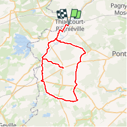
Trail Cycle of 60 km to be discovered at Grand Est, Meurthe-et-Moselle, Thiaucourt-Regniéville. This trail is proposed by tracegps.

Description

Ce circuit vient tout naturellement en complément du circuit n° 12 consacré au Saillant de Saint-Mihiel. Ici, l’itinéraire offre de beaux paysages ruraux au centre de plateaux forestiers du Parc Naturel Régional de Lorraine entre Woëvre et Moselle. L’option vous emmènera jusqu'à l’église de Flirey détruite durant la guerre 1914-1918. Départ du Camping de Thiaucourt-Regniéville ou point info Tourisme à Beaumont. Retrouvez ici le plan et descriptif du circuit. Vous pouvez obtenir le guide par courrier auprès du Parc Naturel Régional de Lorraine.

Elevation profile

Photos

Positioning

Country:
France
Region :
Grand Est
Department/Province :
Meurthe-et-Moselle
Municipality :
Thiaucourt-Regniéville
Location:
Unknown
Start:(UTM)
709793 ; 5426303 (31U) N.

Trails nearby

Trail Cycle Jaulny - La vallée du Rupt de Mad - Circuit n° 14 - Jaulny - Photo
Cycle
tracegps

Cycle

Easy
Jaulny, Grand Est, Meurthe-et-Moselle, France
19.1 km | 22 km-effort
1h 0min
Yes
Trail Cycle Thiaucourt-Regniéville - Les paysages de l'Histoire - Circuit n° 13 - Thiaucourt Regniéville - Photo
Cycle
tracegps

Cycle

Medium
Thiaucourt-Regniéville, Grand Est, Meurthe-et-Moselle, France
49 km | 56 km-effort
2h 30min
Yes
Trail Mountain bike Thiaucourt-Regniéville - Thiaucourt Jaulny Rembercourt - Photo
Mountain bike
kikkko

Mountain bike

Easy
Thiaucourt-Regniéville, Grand Est, Meurthe-et-Moselle, France
16.9 km | 21 km-effort
1h 36min
Yes
Trail Walking Euvezin - Euvezin Bouillonville Thiaucourt et retour par les hauts - Photo
Walking
kikkko

Walking

Medium
Euvezin, Grand Est, Meurthe-et-Moselle, France
10.9 km | 13.5 km-effort
3h 4min
Yes
Trail Walking Viéville-en-Haye - circuit des Rappes - Photo
Walking
kikkko

Walking

Easy
Viéville-en-Haye, Grand Est, Meurthe-et-Moselle, France
13.6 km | 16.2 km-effort
2h 33min
No
Trail Mountain bike Rembercourt-sur-Mad - rembercourt/thiaucourt/AR - Photo
Mountain bike
PascalKvtt

Mountain bike

Medium
Rembercourt-sur-Mad, Grand Est, Meurthe-et-Moselle, France
19.7 km | 25 km-effort
2h 29min
Yes
Trail Horseback riding Pannes - Madine - Photo
Horseback riding
jcvmax

Horseback riding

Very difficult
Pannes, Grand Est, Meurthe-et-Moselle, France
38 km | 47 km-effort
8h 7min
No
Trail Mountain bike Thiaucourt-Regniéville - sortie de thaucourd ctm - Photo
Mountain bike
nouga

Mountain bike

Difficult
Thiaucourt-Regniéville, Grand Est, Meurthe-et-Moselle, France
26 km | 31 km-effort
2h 30min
Yes
Trail Walking Euvezin - Haut d'Euvezin Chapelle de Remenauville - Photo
Walking
kikkko

Walking

Medium
Euvezin, Grand Est, Meurthe-et-Moselle, France
10.9 km | 12.7 km-effort
2h 33min
No


Close
My subscriptions