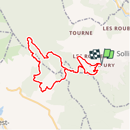
Trail Walking Solliès-Toucas - valaury - Photo
 lygi
lygi

User

© OpenStreetMap contributors
Length
Length
19 km
Max alt
Max alt
780 m
Uphill gradient
Uphill gradient
869 m
Km-Effort
Km-Effort  
31 km
Min alt
Min alt
152 m
Downhill gradient
Downhill gradient
872 m
Boucle
Boucle
Yes
Creation date :
2019-05-06 16:06:14.464
Updated on :
2019-05-06 16:06:14.464

(0 Reviews)

Walking
Walking
--
Difficulty : Medium

Scan this QR Code to open this trail in the SityTrail application

FREE GPS app for hiking

Logo SityTrail SityTrail

IGN / Geographical institutes

Download SityTrail from the App Store Download SityTrail from Google Play

Logo SityTrail SityTrail Plus

The world is yours!

Download SityTrail from the App Store Download SityTrail from Google Play Download SityTrail on Huawei AppGallery

About

Trail Walking of 19 km to be discovered at Provence-Alpes-Côte d'Azur, Var, Solliès-Toucas. This trail is proposed by lygi.

Elevation profile

Points of interest

Point of interest Solliès-Toucas - 01 - Photo
lygi
SOLLIÈS-TOUCAS 
Point of interest Solliès-Toucas - 02 - Photo
lygi
SOLLIÈS-TOUCAS 
Point of interest Le Revest-les-Eaux - a eviter - Photo
lygi
LE REVEST-LES-EAUX 
Point of interest Solliès-Toucas - Apier - Photo
lygi
SOLLIÈS-TOUCAS 
Point of interest Le Revest-les-Eaux - Bories - Photo
lygi
LE REVEST-LES-EAUX 
Point of interest Le Revest-les-Eaux - Carrière - Photo
lygi
LE REVEST-LES-EAUX 

Positioning

Country:
France
Region :
Provence-Alpes-Côte d'Azur
Department/Province :
Var
Municipality :
Solliès-Toucas
Location:
Unknown
Start:(UTM)
256286 ; 4787396 (32T) N.


Close
My subscriptions