Trail Cycle Valognes - Variante Bocage Valognais Est - Photo

Variante Bocage Valognais Est

 tracegps
tracegps

User

© OpenStreetMap contributors
Length
Length
25 km
Max alt
Max alt
125 m
Uphill gradient
Uphill gradient
286 m
Km-Effort
Km-Effort  
29 km
Min alt
Min alt
28 m
Downhill gradient
Downhill gradient
285 m
Boucle
Boucle
Yes
Creation date :
2014-12-10 00:00:00.0
Updated on :
2014-12-10 00:00:00.0

(0 Reviews)

Cycle
Cycle
1h30
Difficulty : Medium

Scan this QR Code to open this trail in the SityTrail application

FREE GPS app for hiking

Logo SityTrail SityTrail

IGN / Geographical institutes

Download SityTrail from the App Store Download SityTrail from Google Play

Logo SityTrail SityTrail World

The world is yours!

Download SityTrail from the App Store Download SityTrail from Google Play Download SityTrail on Huawei AppGallery

About

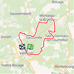
Trail Cycle of 25 km to be discovered at Normandy, Manche, Valognes. This trail is proposed by tracegps.

Description

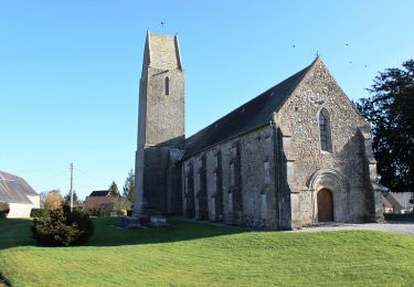
En partant de VALOGNES, ce circuit vous permet de découvrir la commune de HUBERVILLE, ensuite vous arrivez à MONTAIGU-LA-BRISETTE et vous descendez vers la commune de TAMERVILLE pour rejoindre le centre-ville de VALOGNES. Il s'agit d'une variante proposée pour le circuit du Bocage Valognais Côté Est.

Elevation profile

Positioning

Country:
France
Region :
Normandy
Department/Province :
Manche
Municipality :
Valognes
Location:
Unknown
Start:(UTM)
610699 ; 5485172 (30U) N.

Trails nearby

Trail Mountain bike Valognes - La JC M 2010 - Valognes - Photo
Mountain bike
tracegps

Mountain bike

Difficult
(1)
Valognes, Normandy, Manche, France
49 km | 59 km-effort
3h 0min
Yes
Trail Walking Valognes - Valognes - Photo
Walking
PatRando

Walking

Medium
Valognes, Normandy, Manche, France
11.8 km | 13.6 km-effort
2h 12min
Yes
Trail Mountain bike Valognes - La JCM 2013 - randonnée en pays valognais - Photo
Mountain bike
tracegps

Mountain bike

Difficult
Valognes, Normandy, Manche, France
54 km | 66 km-effort
3h 30min
Yes
Trail Mountain bike Valognes - Rando d''Alauna 2013  -  50 km - Valognes - Photo
Mountain bike
tracegps

Mountain bike

Difficult
Valognes, Normandy, Manche, France
47 km | 56 km-effort
2h 30min
No
Trail Mountain bike Saint-Joseph - Le printemps - Saint Joseph - Photo
Mountain bike
tracegps

Mountain bike

Medium
Saint-Joseph, Normandy, Manche, France
35 km | 43 km-effort
2h 0min
Yes
Trail Walking Tamerville - Tamerville - Photo
Walking
PatRando

Walking

Medium
Tamerville, Normandy, Manche, France
17.2 km | 20 km-effort
2h 55min
Yes
Trail Mountain bike Yvetot-Bocage - Rando de Yvetot-Bocage 2013 - Photo
Mountain bike
tracegps

Mountain bike

Medium
Yvetot-Bocage, Normandy, Manche, France
42 km | 47 km-effort
2h 45min
Yes
Trail Mountain bike Sortosville - La Sortosvillaise 2013 - Sortosville - Photo
Mountain bike
tracegps

Mountain bike

Medium
Sortosville, Normandy, Manche, France
27 km | 30 km-effort
2h 0min
Yes
Trail Walking Saint-Joseph - Saint Joseph au château pont Rilly - Photo
Walking
clrunavot

Walking

Medium
Saint-Joseph, Normandy, Manche, France
9.3 km | 11.2 km-effort
2h 33min
Yes


Close
My subscriptions