Trail Walking Alvignac - Le grand tour d'Alvignac Les Eaux - Photo

Le grand tour d'Alvignac Les Eaux

 tracegps
tracegps

User

© OpenStreetMap contributors
Length
Length
15.2 km
Max alt
Max alt
420 m
Uphill gradient
Uphill gradient
306 m
Km-Effort
Km-Effort  
19.3 km
Min alt
Min alt
281 m
Downhill gradient
Downhill gradient
307 m
Boucle
Boucle
Yes
Creation date :
2014-12-10 00:00:00.0
Updated on :
2014-12-10 00:00:00.0

(1 Reviews)

Walking
Walking
3h49
Difficulty : Difficult

Scan this QR Code to open this trail in the SityTrail application

FREE GPS app for hiking

Logo SityTrail SityTrail

IGN / Geographical institutes

Download SityTrail from the App Store Download SityTrail from Google Play

Logo SityTrail SityTrail Plus

The world is yours!

Download SityTrail from the App Store Download SityTrail from Google Play Download SityTrail on Huawei AppGallery

About

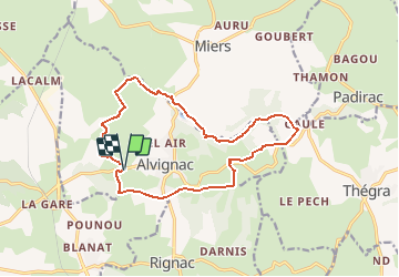
Trail Walking of 15.2 km to be discovered at Occitania, Lot, Alvignac. This trail is proposed by tracegps.

Description

Circuit proposé par la mairie d’Alvignac. Départ du parking de la ferme de Salgues (Face à l’allée des platanes) D 63 sortie d’Alvignac en direction de Rocamadour. Une randonnée pleine de charme, à travers Causse et Limague, agrémentée de beaux points de vue et d’un riche patrimoine local (châteaux, fontaines, lavoirs, cazelle…) Retrouvez le descriptif et le plan sur le site de la mairie.

Elevation profile

Photos

Positioning

Country:
France
Region :
Occitania
Department/Province :
Lot
Municipality :
Alvignac
Location:
Unknown
Start:(UTM)
395679 ; 4964448 (31T) N.

Comments

Please log in to post a review or rate the element


randonnée très agréable, fraiche et ombragée, c'est plutôt rare sur le causse!


Close
My subscriptions