


UTMB4J_tracé2018

jybouteyre
User
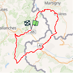

Length
173 km

Max alt
2577 m

Uphill gradient
10190 m
Km-Effort
309 km

Min alt
807 m

Downhill gradient
10190 m
Boucle
Yes
Creation date :
2019-05-06 16:45:43.464
Updated on :
2019-07-01 14:16:49.385
40h00
Difficulty : Very difficult

FREE GPS app for hiking
 SityTrail
IGN / Geographical institutes
SityTrail Plus
The world is yours!
About
Trail Running of 173 km to be discovered at Auvergne-Rhône-Alpes, Upper Savoy, Chamonix-Mont-Blanc. This trail is proposed by jybouteyre.
Positioning
Country:
France
Region :
Auvergne-Rhône-Alpes
Department/Province :
Upper Savoy
Municipality :
Chamonix-Mont-Blanc
Location:
Unknown
Start:(Dec)
Start:(UTM)
334747 ; 5087780 (32T) N.
Comments