


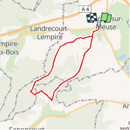
Les 8 chevaux - Dugny-sur-Meuse

tracegps
User


2h45
Difficulty : Medium

FREE GPS app for hiking
 SityTrail
IGN / Geographical institutes
SityTrail Plus
The world is yours!
About
Trail Walking of 10.9 km to be discovered at Grand Est, Meuse, Dugny-sur-Meuse. This trail is proposed by tracegps.
Description
Circuit proposé par l’ Office de Tourisme du Val de Meuse. Départ de la route de Landrecourt, au sud de Dugny-sur-Meuse. Un parcours facile, alliant fraîcheur du bois et ensoleillement dans la plaine avec de beaux points de vue. A parcourir en dehors des périodes de chasse. Retrouvez ce circuit et son descriptif sur le site du Val de Meuse.
Photos


Positioning
Comments