Trail Walking Réchésy - Circuit de Réchésy  - Photo
 tracegps
tracegps

User

© OpenStreetMap contributors
Length
Length
4 km
Max alt
Max alt
451 m
Uphill gradient
Uphill gradient
57 m
Km-Effort
Km-Effort  
4.8 km
Min alt
Min alt
401 m
Downhill gradient
Downhill gradient
60 m
Boucle
Boucle
Yes
Creation date :
2014-12-10 00:00:00.0
Updated on :
2014-12-10 00:00:00.0

(0 Reviews)

Walking
Walking
1h00
Difficulty : Easy

Scan this QR Code to open this trail in the SityTrail application

FREE GPS app for hiking

Logo SityTrail SityTrail

IGN / Geographical institutes

Download SityTrail from the App Store Download SityTrail from Google Play

Logo SityTrail SityTrail World

The world is yours!

Download SityTrail from the App Store Download SityTrail from Google Play Download SityTrail on Huawei AppGallery

About

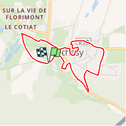
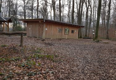
Trail Walking of 4 km to be discovered at Bourgogne-Franche-Comté, Territoire-de-Belfort, Réchésy. This trail is proposed by tracegps.

Description

Circuit proposé par la Communauté de Communes du Sud Territoire. Départ de la salle polyvalente de Réchésy. Retrouvez ce circuit sur le site de la communauté de communes du Sud Territoire.

Elevation profile

Photos

Positioning

Country:
France
Region :
Bourgogne-Franche-Comté
Department/Province :
Territoire-de-Belfort
Municipality :
Réchésy
Location:
Unknown
Start:(UTM)
357592 ; 5263202 (32T) N.

Trails nearby

Trail On foot Bonfol - Bonfol-Damphreux - Photo
On foot
PRO

On foot

Easy
Bonfol, Jura, District de Porrentruy, Switzerland
5 km | 5.9 km-effort
1h 20min
No
Trail Walking Florimont - Circuit de Florimont   - Photo
Walking
tracegps

Walking

Easy
Florimont, Bourgogne-Franche-Comté, Territoire-de-Belfort, France
5.4 km | 6.2 km-effort
1h 30min
Yes
Trail sport Pfetterhouse - Marche Buissonniére - Photo
sport
Fillatre

sport

Very easy
Pfetterhouse, Grand Est, Haut-Rhin, France
8.2 km | 10.3 km-effort
Unknown
Yes
Trail Walking Réchésy - rechesy1 - Photo
Walking
bubu90

Walking

Very easy
Réchésy, Bourgogne-Franche-Comté, Territoire-de-Belfort, France
13.8 km | 17.1 km-effort
2h 41min
Yes
Trail Mountain bike Pfetterhouse - michel - Photo
Mountain bike
rolandwin

Mountain bike

Difficult
(1)
Pfetterhouse, Grand Est, Haut-Rhin, France
42 km | 54 km-effort
3h 21min
Yes
Trail Walking Lepuix-Neuf - lepuix 2021 - Photo
Walking
bubu90

Walking

Medium
Lepuix-Neuf, Bourgogne-Franche-Comté, Territoire-de-Belfort, France
9.5 km | 11.1 km-effort
2h 24min
Yes
Trail Walking Pfetterhouse - km0 pfetterhouse - Photo
Walking
JWeiszrock

Walking

Easy
Pfetterhouse, Grand Est, Haut-Rhin, France
11.7 km | 14.7 km-effort
3h 0min
Yes
Trail Walking Pfetterhouse - pdeter - Photo
Walking
bubu90

Walking

Very easy
Pfetterhouse, Grand Est, Haut-Rhin, France
11.2 km | 13.9 km-effort
2h 22min
Yes
Trail Other activity Florimont - florimont par les ragies - Photo
Other activity
signorato

Other activity

Very easy
Florimont, Bourgogne-Franche-Comté, Territoire-de-Belfort, France
13.1 km | 18 km-effort
5min
Yes


Close
My subscriptions