Trail Walking Brignac - Circuit de Saint Barthélémy  - Brignac - Photo

Circuit de Saint Barthélémy - Brignac

 tracegps
tracegps

User

© OpenStreetMap contributors
Length
Length
11.7 km
Max alt
Max alt
131 m
Uphill gradient
Uphill gradient
106 m
Km-Effort
Km-Effort  
13.1 km
Min alt
Min alt
70 m
Downhill gradient
Downhill gradient
104 m
Boucle
Boucle
Yes
Creation date :
2014-12-10 00:00:00.0
Updated on :
2014-12-10 00:00:00.0

(0 Reviews)

Walking
Walking
3h00
Difficulty : Medium

Scan this QR Code to open this trail in the SityTrail application

FREE GPS app for hiking

Logo SityTrail SityTrail

IGN / Geographical institutes

Download SityTrail from the App Store Download SityTrail from Google Play

Logo SityTrail SityTrail World

The world is yours!

Download SityTrail from the App Store Download SityTrail from Google Play Download SityTrail on Huawei AppGallery

About

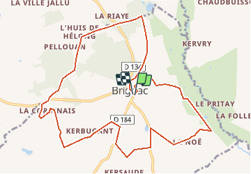
Trail Walking of 11.7 km to be discovered at Brittany, Morbihan, Brignac. This trail is proposed by tracegps.

Description

Point de départ : place de l’église à Brignac - Coordonnées GPS : 02°23’17’’O / 48°07’18’’N - Distance : 12 km - 3 h 00 A voir en chemin: 1. Eglise Saint Barthélémy de Brignac : église paroissiale anciennement dépendante de l’abbaye de Paimpont. Les vitraux datés du XVIème siècle sont classés par les Beaux-Arts. La restauration a permis de découvrir le blason des Bodégat, châtelains de la Riaye en Ménéac, ainsi que celui des Coué. 2. Château et chapelle de la Riaye : le château fut construit en 3 fois, aux XVème, XVIIème et XIXème siècles. Sa chapelle, datée de 1504, est dédiée à Sainte Anne. Son porche est constitué d’une charpente en bois sculpté, reposant sur des colonnettes en granit. 3. La Corbinais : maison du XVIIème siècle construite en schiste, grès et granit. Contact: Office de tourisme du pays de Mauron en Brocéliande. Tel : 02 97 93 05 12 - Email : tourisme (at) valsansretour.com

Elevation profile

Positioning

Country:
France
Region :
Brittany
Department/Province :
Morbihan
Municipality :
Brignac
Location:
Unknown
Start:(UTM)
545568 ; 5329946 (30U) N.

Trails nearby

Trail Walking Ménéac - Circuit de Bellouan - Ménéac - Photo
Walking
tracegps

Walking

Medium
(1)
Ménéac, Brittany, Morbihan, France
7.7 km | 8.9 km-effort
1h 30min
Yes
Trail Nordic walking Ménéac - 2012-02-26 13h59m54 - Photo
Nordic walking
fjalet

Nordic walking

Difficult
(1)
Ménéac, Brittany, Morbihan, France
22 km | 27 km-effort
Unknown
Yes
Trail Mountain bike Ménéac - Rando test FJL - NLB - Photo
Mountain bike
fjalet

Mountain bike

Difficult
Ménéac, Brittany, Morbihan, France
43 km | 51 km-effort
3h 30min
Yes


Close
My subscriptions