Trail Walking Cruguel - Circuit des Picouras - Cruguel - Photo

Circuit des Picouras - Cruguel

 tracegps
tracegps

User

© OpenStreetMap contributors
Length
Length
5.8 km
Max alt
Max alt
161 m
Uphill gradient
Uphill gradient
68 m
Km-Effort
Km-Effort  
6.7 km
Min alt
Min alt
130 m
Downhill gradient
Downhill gradient
79 m
Boucle
Boucle
No
Creation date :
2014-12-10 00:00:00.0
Updated on :
2014-12-10 00:00:00.0

(0 Reviews)

Walking
Walking
2h00
Difficulty : Medium

Scan this QR Code to open this trail in the SityTrail application

FREE GPS app for hiking

Logo SityTrail SityTrail

IGN / Geographical institutes

Download SityTrail from the App Store Download SityTrail from Google Play

Logo SityTrail SityTrail World

The world is yours!

Download SityTrail from the App Store Download SityTrail from Google Play Download SityTrail on Huawei AppGallery

About

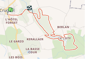
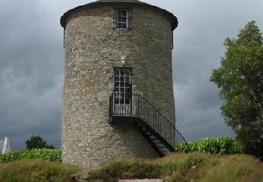
Trail Walking of 5.8 km to be discovered at Brittany, Morbihan, Cruguel. This trail is proposed by tracegps.

Description

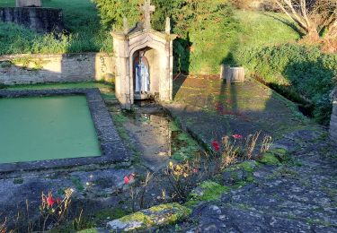
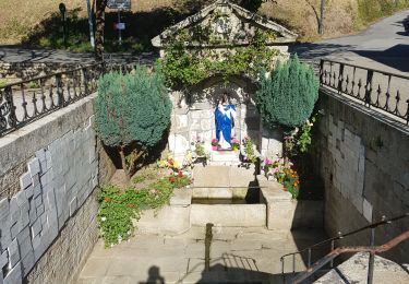
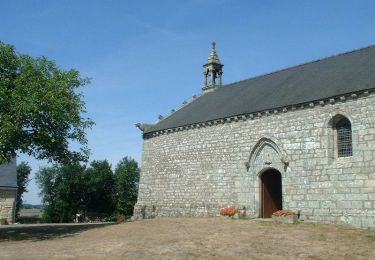
Point de départ : école de Cruguel - Coordonnées GPS : 02°35’41’’O / 47°52’38’’N - Distance : 7 km - 2 h A voir en chemin: En cheminant sur ce circuit, vous apprécierez la beauté d’un patrimoine paysagé préservé. En effet, la vallée du ruisseau de la Chenaie a su garder son caractère naturel. Tout au long de ce circuit ombragé vous emprunterez de magnifiques chemins creux et traverserez prairies, bois et autre village pittoresque. Avant de s’engager sur le parcours, vous pourrez découvrir le centre bourg de Cruguel, commune labellisée « commune du patrimoine rural de Bretagne ». Vous pourrez notamment vous arrêter à la fontaine-lavoir inscrite « monument historique » ainsi que pour admirer les maisons dont certaines ont conservé toute leur authenticité. Contact: Office de tourisme de Josselin . Tel : 02 97 22 36 43 - Email : ot.josselin (at) wanadoo.fr

Elevation profile

Positioning

Country:
France
Region :
Brittany
Department/Province :
Morbihan
Municipality :
Cruguel
Location:
Unknown
Start:(UTM)
530260 ; 5302741 (30T) N.

Trails nearby

Trail Cycle Plumelec - Le petit Codoudal - Plumelec - Photo
Cycle
tracegps

Cycle

Easy
(1)
Plumelec, Brittany, Morbihan, France
12.7 km | 15.5 km-effort
1h 0min
Yes
Trail Walking Guégon - Circuit de Trégranteur - Guégon - Photo
Walking
tracegps

Walking

Medium
(2)
Guégon, Brittany, Morbihan, France
11.1 km | 14.3 km-effort
2h 30min
Yes
Trail Mountain bike Guéhenno - Vélo promenade n°32 - De Guéhenno vers le Lay  - Photo
Mountain bike
tracegps

Mountain bike

Medium
(2)
Guéhenno, Brittany, Morbihan, France
23 km | 27 km-effort
2h 30min
Yes
Trail Walking Plumelec - PR_56_Plumelec_AA_01_Circuit1b_Des-Carrieres_20231128 - Photo
Walking
patrickdanilo

Walking

Easy
Plumelec, Brittany, Morbihan, France
13.3 km | 15.6 km-effort
2h 34min
Yes
Trail Walking Saint-Servant - GR_347_AE_05_St-Servant_Josselin_20190830 - Photo
Walking
patrickdanilo

Walking

Easy
Saint-Servant, Brittany, Morbihan, France
14.4 km | 17.1 km-effort
3h 31min
No
Trail Walking Guéhenno - Autour de Guéhenno - Photo
Walking
tracegps

Walking

Easy
Guéhenno, Brittany, Morbihan, France
6.4 km | 8 km-effort
1h 40min
Yes
Trail On foot Lizio - Sentier des Landes - Photo
On foot
PRO

On foot

Easy
Lizio, Brittany, Morbihan, France
5.2 km | 6.3 km-effort
1h 26min
Yes
Trail Walking Plumelec - Plumelec Cadoudal  - Photo
Walking
motardfou.dgs

Walking

Easy
Plumelec, Brittany, Morbihan, France
7.9 km | 10.1 km-effort
1h 55min
Yes
Trail Walking Billio - billio  - Photo
Walking
motardfou.dgs

Walking

Medium
Billio, Brittany, Morbihan, France
13.1 km | 15.5 km-effort
3h 9min
Yes


Close
My subscriptions