


23.03.2019 - CARENTOIR nord-ouest

babeth35
User
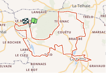

Length
31 km

Max alt
115 m

Uphill gradient
410 m
Km-Effort
36 km

Min alt
25 m

Downhill gradient
420 m
Boucle
Yes
Creation date :
2019-04-29 17:38:40.082
Updated on :
2020-07-20 14:59:03.146
7h53
Difficulty : Medium

FREE GPS app for hiking
 SityTrail
IGN / Geographical institutes
SityTrail Plus
The world is yours!
About
Trail Walking of 31 km to be discovered at Brittany, Morbihan, Carentoir. This trail is proposed by babeth35.
Photos


Positioning
Country:
France
Region :
Brittany
Department/Province :
Morbihan
Municipality :
Carentoir
Location:
Carentoir
Start:(Dec)
Start:(UTM)
560549 ; 5299067 (30T) N.
Comments