


blaison gohier

bubuserge
User
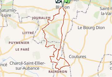

Length
17 km

Max alt
94 m

Uphill gradient
193 m
Km-Effort
19.6 km

Min alt
26 m

Downhill gradient
190 m
Boucle
Yes
Creation date :
2019-05-06 23:11:36.946
Updated on :
2020-05-16 14:30:14.315
--
Difficulty : Unknown

FREE GPS app for hiking
 SityTrail
IGN / Geographical institutes
SityTrail Plus
The world is yours!
About
Trail Walking of 17 km to be discovered at Pays de la Loire, Maine-et-Loire, Blaison-Saint-Sulpice. This trail is proposed by bubuserge.
Positioning
Country:
France
Region :
Pays de la Loire
Department/Province :
Maine-et-Loire
Municipality :
Blaison-Saint-Sulpice
Location:
Blaison-Gohier
Start:(Dec)
Start:(UTM)
698360 ; 5252958 (30T) N.
Comments