Trail Cycle Troyes - Les Côtes de Troyes en Champagne - Photo

Les Côtes de Troyes en Champagne

 tracegps
tracegps

User

© OpenStreetMap contributors
Length
Length
57 km
Max alt
Max alt
306 m
Uphill gradient
Uphill gradient
539 m
Km-Effort
Km-Effort  
65 km
Min alt
Min alt
103 m
Downhill gradient
Downhill gradient
538 m
Boucle
Boucle
Yes
Creation date :
2014-12-10 00:00:00.0
Updated on :
2014-12-10 00:00:00.0

(0 Reviews)

Cycle
Cycle
3h30
Difficulty : Medium

Scan this QR Code to open this trail in the SityTrail application

FREE GPS app for hiking

Logo SityTrail SityTrail

IGN / Geographical institutes

Download SityTrail from the App Store Download SityTrail from Google Play

Logo SityTrail SityTrail World

The world is yours!

Download SityTrail from the App Store Download SityTrail from Google Play Download SityTrail on Huawei AppGallery

About

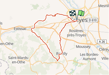
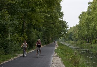
Trail Cycle of 57 km to be discovered at Grand Est, Aube, Troyes. This trail is proposed by tracegps.

Description

Proposé par le Comité Départemental du Tourisme de l'Aube, un circuit créé et validé par la Fédération Départementale du Cyclotourisme de l’Aube. Les Côtes de Troyes en Champagne – 58 km - Lavoirs de Bucey-en-Othe et Fontvannes - Vignoble de Montgueux - Forêts du Pays d’Othe - Église de St André les Vergers - Église de Ste Savine

Elevation profile

Photos

Points of interest

Positioning

Country:
France
Region :
Grand Est
Department/Province :
Aube
Municipality :
Troyes
Location:
Unknown
Start:(Dec)
Start:(UTM)
579048 ; 5349740 (31U) N.

Trails nearby

Trail Nordic walking Bréviandes - Breviandes cimetière 9-04 -30 - Photo
Nordic walking
martineaufrancois

Nordic walking

Very easy
(1)
Bréviandes, Grand Est, Aube, France
12.1 km | 13.1 km-effort
1h 8min
Yes
Trail Nordic walking Saint-André-les-Vergers - sortie Mercredi soir ECH - Photo
Nordic walking
LANDRE0774

Nordic walking

Easy
(1)
Saint-André-les-Vergers, Grand Est, Aube, France
8.8 km | 9.4 km-effort
1h 30min
Yes
Trail Walking Troyes - troyes - Photo
Walking
pistou

Walking

Medium
Troyes, Grand Est, Aube, France
6.7 km | 7.2 km-effort
3h 9min
Yes
Trail Walking Pont-Sainte-Marie - PSM Villacerf 22,5km - Photo
Walking
francis1952

Walking

Difficult
Pont-Sainte-Marie, Grand Est, Aube, France
23 km | 24 km-effort
4h 6min
Yes
Trail Walking Bréviandes - Rosieres - Photo
Walking
FPortier

Walking

Very easy
Bréviandes, Grand Est, Aube, France
3.3 km | 3.5 km-effort
51min
No
Trail Walking Troyes - Troyes les 10 églises le 16/02/2020 - Photo
Walking
francis1952

Walking

Easy
Troyes, Grand Est, Aube, France
12.5 km | 13.6 km-effort
2h 42min
Yes
Trail Cycle Troyes - Canal de la Haute Seine - Troyes - Photo
Cycle
tracegps

Cycle

Medium
Troyes, Grand Est, Aube, France
61 km | 66 km-effort
2h 30min
Yes
Trail Nordic walking Saint-André-les-Vergers - voie des viennes - Photo
Nordic walking
LANDRE0774

Nordic walking

Easy
Saint-André-les-Vergers, Grand Est, Aube, France
4.2 km | 4.6 km-effort
50min
No
Trail Mountain bike Troyes - tour Montgueuliatte  16/5/21 - Photo
Mountain bike
Tollard

Mountain bike

Easy
Troyes, Grand Est, Aube, France
41 km | 48 km-effort
3h 9min
Yes


Close
My subscriptions