


LINCEL Moulin de l Agnelier

RobinMicheline
User GUIDE
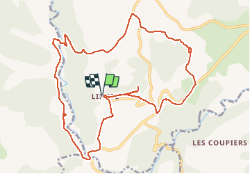

Length
13.6 km

Max alt
593 m

Uphill gradient
316 m
Km-Effort
17.8 km

Min alt
442 m

Downhill gradient
317 m
Boucle
Yes
Creation date :
2019-05-16 07:39:31.259
Updated on :
2020-04-01 16:21:36.822
6h22
Difficulty : Easy

FREE GPS app for hiking
 SityTrail
IGN / Geographical institutes
SityTrail Plus
The world is yours!
About
Trail Walking of 13.6 km to be discovered at Provence-Alpes-Côte d'Azur, Alpes-de-Haute-Provence, Saint-Michel-l'Observatoire. This trail is proposed by RobinMicheline.
Description
13 kms 5 h
Positioning
Country:
France
Region :
Provence-Alpes-Côte d'Azur
Department/Province :
Alpes-de-Haute-Provence
Municipality :
Saint-Michel-l'Observatoire
Location:
Lincel
Start:(Dec)
Start:(UTM)
717379 ; 4863198 (31T) N.
Comments