Trail Walking Ygrande - Circuit Neverdière - Ygrande - Photo

Circuit Neverdière - Ygrande

 tracegps
tracegps

User

© OpenStreetMap contributors
Length
Length
10.4 km
Max alt
Max alt
346 m
Uphill gradient
Uphill gradient
153 m
Km-Effort
Km-Effort  
12.4 km
Min alt
Min alt
264 m
Downhill gradient
Downhill gradient
153 m
Boucle
Boucle
Yes
Creation date :
2014-12-10 00:00:00.0
Updated on :
2014-12-10 00:00:00.0

(0 Reviews)

Walking
Walking
2h34
Difficulty : Medium

Scan this QR Code to open this trail in the SityTrail application

FREE GPS app for hiking

Logo SityTrail SityTrail

IGN / Geographical institutes

Download SityTrail from the App Store Download SityTrail from Google Play

Logo SityTrail SityTrail World

The world is yours!

Download SityTrail from the App Store Download SityTrail from Google Play Download SityTrail on Huawei AppGallery

About

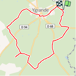
Trail Walking of 10.4 km to be discovered at Auvergne-Rhône-Alpes, Allier, Ygrande. This trail is proposed by tracegps.

Description

Circuit proposé par l'association Chemins d'Issards. Le nom d'Ygrande tens à démontrer qu'à l'époque gauloise le village se situait à la frontière séparant les Bituriges (Berry) et les Arvernes (Auvergne). Le bourg a également la curieuse particularité d'être à cheval sur la ligne de partage des eaux entre le bassin de l'Allier et celui du Cher. Départ du musée Emile Guillaumin. Retrouvez le circuit et son descriptif le site de l'association Chemins d'Issards.

Elevation profile

Photos

Positioning

Country:
France
Region :
Auvergne-Rhône-Alpes
Department/Province :
Allier
Municipality :
Ygrande
Location:
Unknown
Start:(UTM)
496715 ; 5155421 (31T) N.

Trails nearby

Trail Other activity Gipcy - st hilaire grobois pont de villemier - Photo
Other activity
gregory03

Other activity

Very difficult
Gipcy, Auvergne-Rhône-Alpes, Allier, France
14.5 km | 17.7 km-effort
2h 38min
Yes
Trail Equestrian Ygrande - souvignyygrande - Photo
Equestrian
pierrethepot

Equestrian

Easy
(1)
Ygrande, Auvergne-Rhône-Alpes, Allier, France
27 km | 31 km-effort
4h 39min
No
Trail Equestrian Ygrande - rando mathilde retour - Photo
Equestrian
pierrethepot

Equestrian

Very easy
Ygrande, Auvergne-Rhône-Alpes, Allier, France
22 km | 26 km-effort
3h 14min
No
Trail On foot Ygrande - Ygrande - Photo
On foot
fenka

On foot

Easy
Ygrande, Auvergne-Rhône-Alpes, Allier, France
1.8 km | 1.9 km-effort
26min
No


Close
My subscriptions