


trail plat bord de Rhone

ggtasie
User

Length
8.9 km

Max alt
168 m

Uphill gradient
64 m
Km-Effort
9.7 km

Min alt
150 m

Downhill gradient
64 m
Boucle
Yes
Creation date :
2019-05-06 23:27:29.434
Updated on :
2019-05-06 23:27:29.434
46m
Difficulty : Very easy

FREE GPS app for hiking
 SityTrail
IGN / Geographical institutes
SityTrail Plus
The world is yours!
About
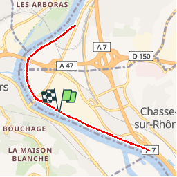
Trail Other activity of 8.9 km to be discovered at Auvergne-Rhône-Alpes, Isère, Chasse-sur-Rhône. This trail is proposed by ggtasie.
Positioning
Country:
France
Region :
Auvergne-Rhône-Alpes
Department/Province :
Isère
Municipality :
Chasse-sur-Rhône
Location:
Unknown
Start:(Dec)
Start:(UTM)
639384 ; 5048948 (31T) N.
Comments