


Romeyer Pas des Econdus

ajd26
User

Length
19.7 km

Max alt
1540 m

Uphill gradient
1145 m
Km-Effort
35 km

Min alt
560 m

Downhill gradient
1142 m
Boucle
Yes
Creation date :
2019-05-19 18:03:04.973
Updated on :
2019-05-19 18:03:05.149
6h00
Difficulty : Difficult

FREE GPS app for hiking
 SityTrail
IGN / Geographical institutes
SityTrail Plus
The world is yours!
About
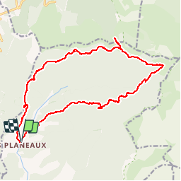
Trail Walking of 19.7 km to be discovered at Auvergne-Rhône-Alpes, Drôme, Romeyer. This trail is proposed by ajd26.
Description
Depuis le hameau des Planeaux, col de la Pouterie, col du Pré, aller retour au pas des Econdus et retour par la descente du pas de Chabrinel
Positioning
Country:
France
Region :
Auvergne-Rhône-Alpes
Department/Province :
Drôme
Municipality :
Romeyer
Location:
Unknown
Start:(Dec)
Start:(UTM)
690457 ; 4962911 (31T) N.
Comments