Trail Walking Saint-Germain-de-Salles - Les écluses - Photo
 Gegetop
Gegetop

User

© OpenStreetMap contributors
Length
Length
12.4 km
Max alt
Max alt
295 m
Uphill gradient
Uphill gradient
82 m
Km-Effort
Km-Effort  
13.5 km
Min alt
Min alt
270 m
Downhill gradient
Downhill gradient
82 m
Boucle
Boucle
Yes
Creation date :
2019-05-06 23:36:16.51
Updated on :
2019-05-06 23:36:16.51

(0 Reviews)

Walking
Walking
2h57
Difficulty : Easy

Scan this QR Code to open this trail in the SityTrail application

FREE GPS app for hiking

Logo SityTrail SityTrail

IGN / Geographical institutes

Download SityTrail from the App Store Download SityTrail from Google Play

Logo SityTrail SityTrail World

The world is yours!

Download SityTrail from the App Store Download SityTrail from Google Play Download SityTrail on Huawei AppGallery

About

Trail Walking of 12.4 km to be discovered at Auvergne-Rhône-Alpes, Allier, Saint-Germain-de-Salles. This trail is proposed by Gegetop.

Description

En partie sur le PR13

Elevation profile

Photos

Positioning

Country:
France
Region :
Auvergne-Rhône-Alpes
Department/Province :
Allier
Municipality :
Saint-Germain-de-Salles
Location:
Unknown
Start:(UTM)
515779 ; 5113518 (31T) N.

Trails nearby

Trail Walking Charroux - Moulin de Parrot - Photo
Walking
Vincent Bicard

Walking

Medium
Charroux, Auvergne-Rhône-Alpes, Allier, France
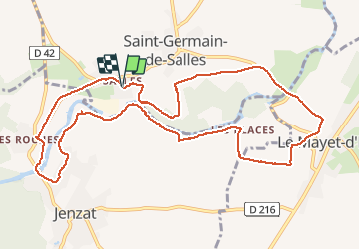
14 km | 17.7 km-effort
3h 22min
Yes
Trail Walking Charroux - Le Moulin Parraud  - Photo
Walking
Gegetop

Walking

Easy
Charroux, Auvergne-Rhône-Alpes, Allier, France
13 km | 16.5 km-effort
3h 30min
Yes
Trail Walking Saint-Bonnet-de-Rochefort - les tressots - Photo
Walking
patrickboisard

Walking

Medium
Saint-Bonnet-de-Rochefort, Auvergne-Rhône-Alpes, Allier, France
6.6 km | 8.6 km-effort
1h 37min
Yes
Trail Walking Charroux - Randonnée à Charroux, Vichy, 2023 - Photo
Walking
ezola

Walking

Difficult
Charroux, Auvergne-Rhône-Alpes, Allier, France
13.2 km | 16.7 km-effort
3h 22min
No
Trail Mountain bike Broût-Vernet - top - Photo
Mountain bike
ricodal

Mountain bike

Very easy
Broût-Vernet, Auvergne-Rhône-Alpes, Allier, France
34 km | 44 km-effort
3h 3min
No
Trail Walking Charroux - GR de Pays Val de Sioule - Photo
Walking
loursblanc

Walking

Easy
Charroux, Auvergne-Rhône-Alpes, Allier, France
77 km | 100 km-effort
20h 0min
Yes
Trail Walking Charroux - GR de Pays Val de Sioule - Photo
Walking
loursblanc

Walking

Easy
Charroux, Auvergne-Rhône-Alpes, Allier, France
77 km | 100 km-effort
20h 0min
Yes
Trail Other activity Charroux - charroux  - Photo
Other activity
kronio

Other activity

Easy
Charroux, Auvergne-Rhône-Alpes, Allier, France
9.1 km | 13 km-effort
3h 21min
Yes
Trail Walking Charroux - charroux 2 em marche  - Photo
Walking
jjf

Walking

Very easy
Charroux, Auvergne-Rhône-Alpes, Allier, France
5.9 km | 7.4 km-effort
1h 9min
Yes


Close
My subscriptions