


par monts et forêts. Malans

eltonnermou
User
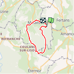

Length
9.8 km

Max alt
601 m

Uphill gradient
199 m
Km-Effort
12.5 km

Min alt
424 m

Downhill gradient
210 m
Boucle
Yes
Creation date :
2019-05-06 23:36:32.833
Updated on :
2019-05-06 23:36:32.833
1h41
Difficulty : Easy

FREE GPS app for hiking
 SityTrail
IGN / Geographical institutes
SityTrail Plus
The world is yours!
About
Trail Walking of 9.8 km to be discovered at Bourgogne-Franche-Comté, Doubs, Malans. This trail is proposed by eltonnermou.
Description
randonnée non balisée, avec courte partie hors sentier. de beaux sous bois et quelques points de vue
Positioning
Country:
France
Region :
Bourgogne-Franche-Comté
Department/Province :
Doubs
Municipality :
Malans
Location:
Unknown
Start:(Dec)
Start:(UTM)
275548 ; 5214242 (32T) N.
Comments