Trail Walking Auberville - Sentier nature des vaches noires - Photo

Sentier nature des vaches noires

© OpenStreetMap contributors
Length
Length
1.7 km
Max alt
Max alt
126 m
Uphill gradient
Uphill gradient
50 m
Km-Effort
Km-Effort  
2.3 km
Min alt
Min alt
75 m
Downhill gradient
Downhill gradient
49 m
Boucle
Boucle
Yes
Creation date :
2019-04-02 12:16:56.815
Updated on :
2019-04-02 12:16:56.815

(2 Reviews)

Walking
Walking
30m
Difficulty : Easy

Scan this QR Code to open this trail in the SityTrail application

FREE GPS app for hiking

Logo SityTrail SityTrail

IGN / Geographical institutes

Download SityTrail from the App Store Download SityTrail from Google Play

Logo SityTrail SityTrail World

The world is yours!

Download SityTrail from the App Store Download SityTrail from Google Play Download SityTrail on Huawei AppGallery

About

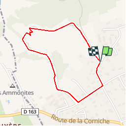
Trail Walking of 1.7 km to be discovered at Normandy, Calvados, Auberville. This trail is proposed by neoroll44.

Description

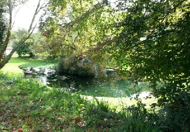
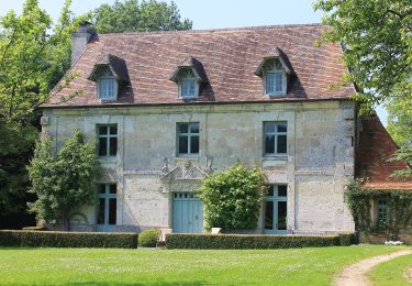
Sur ce plateau, les prairies bocagères révèlent une nature marquée par l'empreinte de l'homme. La végétation est en forte reconquête dans les vallons où l’impression de naturalité est très présente, allant jusqu’à coloniser certains anciens édifices datant ou non de la seconde guerre mondiale.
1. Début du chemin au niveau du panneau du Conservatoire du littoral, chemin de l’église, prendre ce chemin descendant.
2. Le chemin s’élargit : rester sur le côté gauche du chemin (parcelle en herbe).
3. Prendre à gauche pour monter un large escalier en bois, après l’escalier continuer en obliquant légèrement vers la droite, dans une zone boisée.
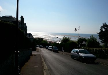
4. En sortant de la zone boisée, (panorama sur la mer) descendre la pente en direction de la mer en longeant une clôture, suivre le sentier vers un platelage en bois, continuer sur 80 mètres après le platelage.
5. Prendre à gauche et remonter le sentier jusqu’à la barrière située en haut du champ.
6. Passer la barrière sur la droite. Prendre le chemin sur 200 mètres.
7. Franchir une autre barrière et faire 150 mètres jusqu’à la route. Prendre à gauche sur le chemin Blandin.
8. Prendre à gauche au croisement pour reprendre le chemin de l’église, suivre cette route jusqu’au point de départ.

Elevation profile

Points of interest

Point of interest Auberville - 1 - Photo
neoroll44
AUBERVILLE 
Point of interest Auberville - 2 - Photo
neoroll44
AUBERVILLE 
Point of interest Auberville - 3 - Photo
neoroll44
AUBERVILLE 
Point of interest Auberville - 4 - Photo
neoroll44
AUBERVILLE 
Point of interest Auberville - 5 - Photo
neoroll44
AUBERVILLE 
Point of interest Auberville - 6 - Photo
neoroll44
AUBERVILLE 
Point of interest Auberville - 7 - Photo
neoroll44
AUBERVILLE 
Point of interest Auberville - 8 - Photo
neoroll44
AUBERVILLE 

Positioning

Country:
France
Region :
Normandy
Department/Province :
Calvados
Municipality :
Auberville
Location:
Unknown
Start:(UTM)
715665 ; 5466234 (30U) N.

Comments

Please log in to post a review or rate the element


nous avons été très déçus, aucune visibilité des falaises. joli dégagement sur la mer, mais dans la région cela se trouve facilement.


Trails nearby

Trail Walking Houlgate - falaises les vaches noir - Photo
Walking
ebihr4

Walking

Medium
(2)
Houlgate, Normandy, Calvados, France
11.9 km | 13.9 km-effort
4h 7min
Yes
Trail Walking Houlgate - Houlgate - Photo
Walking
Roulland

Walking

Easy
(1)
Houlgate, Normandy, Calvados, France
14.5 km | 19.9 km-effort
4h 5min
Yes
Trail Walking Blonville-sur-Mer - Blonville 2 - Photo
Walking
phi14

Walking

Very easy
(1)
Blonville-sur-Mer, Normandy, Calvados, France
8.3 km | 10.1 km-effort
2h 11min
Yes
Trail Walking Villers-sur-Mer - Villers Sur mer  - Photo
Walking
phi14

Walking

Very easy
(1)
Villers-sur-Mer, Normandy, Calvados, France
9.7 km | 10.9 km-effort
2h 35min
Yes
Trail Walking Houlgate - w-frankrijk-houlgate-fossielenroute - Photo
Walking
gpstracks

Walking

Very easy
(1)
Houlgate, Normandy, Calvados, France
12.1 km | 14.3 km-effort
Unknown
Yes
Trail On foot  - Chemins Creux et Pans de Bois - Photo
On foot
PRO

On foot

Easy
, Normandy, Calvados, France
6.4 km | 7.8 km-effort
1h 46min
Yes
Trail On foot Dives-sur-Mer - De Marcel Proust à Guillaume le Conquérant - Photo
On foot
PRO

On foot

Easy
Dives-sur-Mer, Normandy, Calvados, France
3.3 km | 3.6 km-effort
48min
No
Trail On foot Houlgate - Mer et Campagne - Photo
On foot
PRO

On foot

Easy
(1)
Houlgate, Normandy, Calvados, France
10 km | 13.8 km-effort
3h 8min
Yes
Trail On foot Houlgate - Le Tour de Houlgate - Photo
On foot
PRO

On foot

Easy
Houlgate, Normandy, Calvados, France
11.4 km | 15.2 km-effort
3h 26min
Yes


Close
My subscriptions