Trail Walking Montépilloy - Une grande échappée - Montépilloy - Photo

Une grande échappée - Montépilloy

 tracegps
tracegps

User

© OpenStreetMap contributors
Length
Length
9.7 km
Max alt
Max alt
151 m
Uphill gradient
Uphill gradient
97 m
Km-Effort
Km-Effort  
11 km
Min alt
Min alt
82 m
Downhill gradient
Downhill gradient
97 m
Boucle
Boucle
Yes
Creation date :
2014-12-10 00:00:00.0
Updated on :
2014-12-10 00:00:00.0

(1 Reviews)

Walking
Walking
2h30
Difficulty : Medium

Scan this QR Code to open this trail in the SityTrail application

FREE GPS app for hiking

Logo SityTrail SityTrail

IGN / Geographical institutes

Download SityTrail from the App Store Download SityTrail from Google Play

Logo SityTrail SityTrail Plus

The world is yours!

Download SityTrail from the App Store Download SityTrail from Google Play Download SityTrail on Huawei AppGallery

About

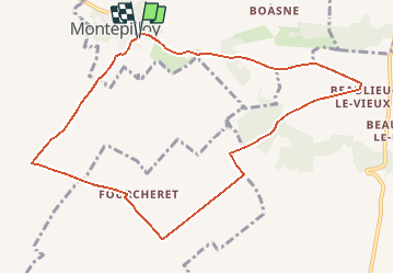
Trail Walking of 9.7 km to be discovered at Hauts-de-France, Oise, Montépilloy. This trail is proposed by tracegps.

Description

Circuit proposé par le Parc Naturel régional Oise – Pays de France. Les romains nommèrent ce site stratégique, Mons Expellericus pour ses qualités de guet. Sentinelle déchue, le formidable donjon de Montépilloy (45 m de haut), bâti au 12e siècle, domine toute la plaine du Valois et se souvient encore de sa gloire passée, lorsque Jeanne d’Arc, de retour du couronnement de Charles VII à Reims, bâtit les Anglais sous ses murs en 1429. Départ : Parking du cimetière de Montépilloy, Retrouvez le circuit sur le site du Parc Naturel régional Oise – Pays de France.

Elevation profile

Photos

Positioning

Country:
France
Region :
Hauts-de-France
Department/Province :
Oise
Municipality :
Montépilloy
Location:
Unknown
Start:(UTM)
478170 ; 5450672 (31U) N.

Comments

Please log in to post a review or rate the element


Close
My subscriptions