


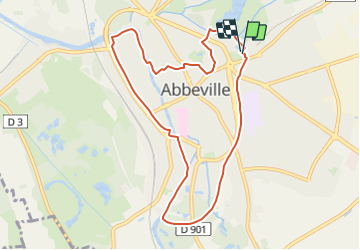
LP80_ABBEVILLE_Ronde-de-l'eau_8.5km

BAIE de SOMME & alentours
Autour de la Baie à pieds


2h01
Difficulty : Medium

FREE GPS app for hiking
 SityTrail
IGN / Geographical institutes
SityTrail Plus
The world is yours!
About
Trail Walking of 8.5 km to be discovered at Hauts-de-France, Somme, Abbeville. This trail is proposed by BAIE de SOMME & alentours.
Description
Une boucle autour
d’un fleuve, de rivières,
de rus, d’étangs et de
marais... un rappel que
l’eau est reine dans la
capitale du Ponthieu !
Départ : Kiosque, à côté de la piscine d’Abbeville.
AUTEUR TRACE GPS.com
http://www.tracegps.com/fr/parcours/circuit1485.htm#
Fiche N°1 à l'Office du tourisme d'Abbeville.
Ce circuit est entretenu
par la ville d’Abbeville.
Photos

Positioning
Comments