


CHABRIERES Pas de l Ane Entrages Pas des Portes clubs navette

RobinMicheline
User GUIDE
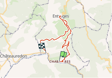

Length
15.5 km

Max alt
1040 m

Uphill gradient
761 m
Km-Effort
26 km

Min alt
607 m

Downhill gradient
784 m
Boucle
No
Creation date :
2019-05-16 07:39:25.25
Updated on :
2020-04-01 16:38:20.524
6h49
Difficulty : Medium

FREE GPS app for hiking
 SityTrail
IGN / Geographical institutes
SityTrail Plus
The world is yours!
About
Trail Walking of 15.5 km to be discovered at Provence-Alpes-Côte d'Azur, Alpes-de-Haute-Provence, Entrages. This trail is proposed by RobinMicheline.
Description
16 kms 750 M 320 mns marche magnifique petits sentiers belle vue A refaite


Positioning
Country:
France
Region :
Provence-Alpes-Côte d'Azur
Department/Province :
Alpes-de-Haute-Provence
Municipality :
Entrages
Location:
Unknown
Start:(Dec)
Start:(UTM)
280786 ; 4876670 (32T) N.
Comments