Trail Walking Entrages - CHABRIERES Pas de l Ane Entrages Pas des Portes clubs navette  - Photo

CHABRIERES Pas de l Ane Entrages Pas des Portes clubs navette

© OpenStreetMap contributors
Length
Length
15.5 km
Max alt
Max alt
1040 m
Uphill gradient
Uphill gradient
761 m
Km-Effort
Km-Effort  
26 km
Min alt
Min alt
607 m
Downhill gradient
Downhill gradient
784 m
Boucle
Boucle
No
Creation date :
2019-05-16 07:39:25.25
Updated on :
2020-04-01 16:38:20.524

(1 Reviews)

Walking
Walking
6h49
Difficulty : Medium

Scan this QR Code to open this trail in the SityTrail application

FREE GPS app for hiking

Logo SityTrail SityTrail

IGN / Geographical institutes

Download SityTrail from the App Store Download SityTrail from Google Play

Logo SityTrail SityTrail World

The world is yours!

Download SityTrail from the App Store Download SityTrail from Google Play Download SityTrail on Huawei AppGallery

About

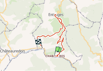
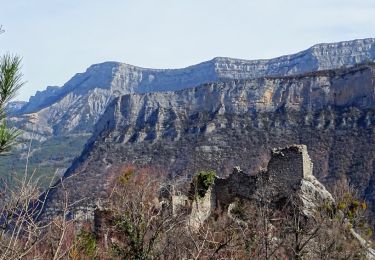
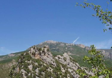
Trail Walking of 15.5 km to be discovered at Provence-Alpes-Côte d'Azur, Alpes-de-Haute-Provence, Entrages. This trail is proposed by RobinMicheline.

Description

16 kms 750 M 320 mns marche magnifique petits sentiers belle vue A refaite

Elevation profile

Points of interest

Point of interest Entrages - Point 1 - Photo
RobinMicheline
ENTRAGES 

Positioning

Country:
France
Region :
Provence-Alpes-Côte d'Azur
Department/Province :
Alpes-de-Haute-Provence
Municipality :
Entrages
Location:
Unknown
Start:(UTM)
280786 ; 4876670 (32T) N.

Comments

Please log in to post a review or rate the element


Trails nearby

Trail Walking Chaudon-Norante - ENTRAGES la Clappe départ ancienne carrière Gozzi - Photo
Walking
RobinMicheline

Walking

Medium
(1)
Chaudon-Norante, Provence-Alpes-Côte d'Azur, Alpes-de-Haute-Provence, France
12.8 km | 19.9 km-effort
4h 7min
Yes
Trail Walking Beynes - 2023-03-17 Montagne de Beyne - Photo
Walking
GUIDE
Kargil

Walking

Medium
Beynes, Provence-Alpes-Côte d'Azur, Alpes-de-Haute-Provence, France
14.4 km | 26 km-effort
6h 28min
Yes
Trail Walking Beynes - 04 La montagne de Beynes (Variante 05/2022) - Photo
Walking
chris13370

Walking

Medium
Beynes, Provence-Alpes-Côte d'Azur, Alpes-de-Haute-Provence, France
12.9 km | 23 km-effort
7h 15min
Yes
Trail On foot Entrages - Le Sommet du Cousson - Photo
On foot
PRO

On foot

Medium
Entrages, Provence-Alpes-Côte d'Azur, Alpes-de-Haute-Provence, France
11.8 km | 21 km-effort
4h 50min
Yes
Trail Walking Chaudon-Norante - Ruines hameau Creisset par Passerelle Asse - Photo
Walking
GrouGary

Walking

Easy
Chaudon-Norante, Provence-Alpes-Côte d'Azur, Alpes-de-Haute-Provence, France
8.8 km | 15.2 km-effort
4h 14min
No
Trail Walking Chaudon-Norante - Hameau de Creisset - Photo
Walking
Nicomontagnes

Walking

Very easy
(1)
Chaudon-Norante, Provence-Alpes-Côte d'Azur, Alpes-de-Haute-Provence, France
9.5 km | 15.6 km-effort
3h 39min
Yes
Trail Equestrian Chaudon-Norante - La Voie Impériale (Etape 3 : Chaudon-Norante (La Clappe) - Digne-les-Bains) - Photo
Equestrian
tracegps

Equestrian

Difficult
(1)
Chaudon-Norante, Provence-Alpes-Côte d'Azur, Alpes-de-Haute-Provence, France
14 km | 21 km-effort
3h 45min
No
Trail Walking Chaudon-Norante - La Voie Impériale (Etape 3 : Chaudon-Norante (La Clappe) - Digne-les-Bains) - Photo
Walking
tracegps

Walking

Difficult
Chaudon-Norante, Provence-Alpes-Côte d'Azur, Alpes-de-Haute-Provence, France
14 km | 21 km-effort
4h 30min
No
Trail Walking Beynes - Boucle de Palus - Beynes - Photo
Walking
tracegps

Walking

Medium
Beynes, Provence-Alpes-Côte d'Azur, Alpes-de-Haute-Provence, France
7.8 km | 11 km-effort
2h 0min
Yes


Close
My subscriptions