


sarrigné

bubuserge
User
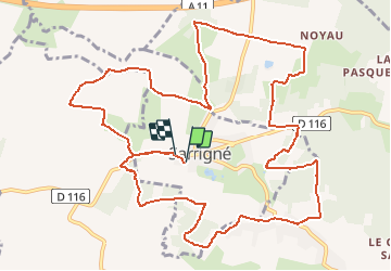

Length
14.8 km

Max alt
61 m

Uphill gradient
135 m
Km-Effort
16.6 km

Min alt
24 m

Downhill gradient
132 m
Boucle
Yes
Creation date :
2019-05-06 23:58:42.644
Updated on :
2020-05-16 14:30:10.151
--
Difficulty : Medium

FREE GPS app for hiking
 SityTrail
IGN / Geographical institutes
SityTrail Plus
The world is yours!
About
Trail Walking of 14.8 km to be discovered at Pays de la Loire, Maine-et-Loire, Sarrigné. This trail is proposed by bubuserge.
Positioning
Country:
France
Region :
Pays de la Loire
Department/Province :
Maine-et-Loire
Municipality :
Sarrigné
Location:
Unknown
Start:(Dec)
Start:(UTM)
696816 ; 5264112 (30T) N.
Comments